Nizāmābād elevation
Nizāmābād (Telangana, Nizamabad), India elevation is 389 meters and Nizāmābād elevation in feet is 1276 ft above sea level [src 1]. Nizāmābād is a populated place (feature code) with elevation that is 96 meters (315 ft) bigger than average city elevation in India.
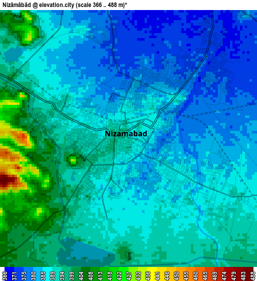
Below is the Elevation map of Nizāmābād, which displays elevation range with different colors. Scale of the first map is from 366 to 488 m (1201 to 1601 ft) with average elevation of 389.1 meters (=1277 ft) [note 1]
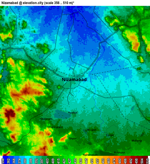
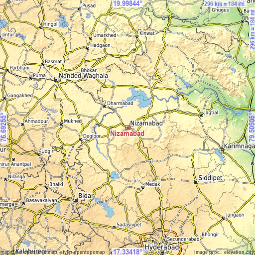
These maps also provides idea of topography and contour of this city, they are displayed at different zoom levels. More info about maps, scale and edge coordinates you can find below images.
| \ | Map #1 | Map #2 | Topo.Map |
| Scale [m] | 366..488 m | 356..510 m | × |
| Scale [ft] | 1201..1601 ft | 1168..1673 ft | × |
| Average | 389.1 m = 1277 ft | 400.3 m = 1313 ft | × |
| Width | 9.26 km = 5.8 mi | 18.52 km = 11.5 mi | 296.2 km = 184 mi |
| Height | 9.26 km = 5.8 mi | 18.52 km = 11.5 mi | 296.3 km = 184.1 mi |
| ↑Max Latitude | 18.713167° | 18.754784° | 19.99844° |
| Latitude at center | 18.67154° | 18.67154° | 18.67154° |
| ↓Min Latitude | 18.629902° | 18.588255° | 17.33418° |
| ← Min Longitude | 78.054855° | 78.010909° | 76.69255° |
| Longitude center | 78.0988° | 78.0988° | 78.0988° |
| →Max Longitude | 78.142745° | 78.186691° | 79.50505° |
Nearby cities:
Cities around Nizāmābād sort by population:
• Nirmal elevation 338 m
53.9 km,  28°
28°
• Bodhan 375 m
22.5 km,  267°
267°
• Kāmāreddi 523 m
46.7 km,  146°
146°
• Koratla 301 m
66.7 km,  75°
75°
• Dīglūr 383 m
56.7 km,  256°
256°
• Bhaisa 369 m
51.1 km,  343°
343°
• Medak 474 m
71.7 km,  166°
166°
• Dharmābād 360 m
35.9 km,  312°
312°
• Mukher 404 m
77.1 km, 272°
• Bānswāda 387 m
40 km,  215°
215°
• Kondalwādi 361 m
37.7 km,  293°
293°
• Biloli 371 m
41 km, 286°
Multilingual:
 En español:
Nizāmābād elevación 389 m.
 En France:
Nizāmābād élévation 389 m.
 Auf Deutsch:
Nizāmābād höhe über dem Meeresspiegel ist 389 m.

Sources and notes:
- [note 1] Map square and city borders are not equal. Map elevation data is calculated only from area inside that square.
- [src 1] Elevation data from geonames database provided with same terms of usage.
- [src 2] The elevation map of Nizāmābād is generated using elevation data from NASA's 3 arcsec (90m) resolution SRTM data.
- [src 3] Base (background) map © OpenStreetMap contributors tiles are generated by Geofabrik and OpenTopoMap.
Copyright & License:
This Nizāmābād Elevation Map is licensed under CC BY-SA. You may reuse any part from this page, if you give a proper credit by linking to this URL:
 More info on terms of use page.