Rājmahal elevation
Rājmahal (West Bengal), India elevation is 34 meters and Rājmahal elevation in feet is 112 ft above sea level [src 1]. Rājmahal is a populated place (feature code) with elevation that is 259 meters (850 ft) smaller than average city elevation in India.
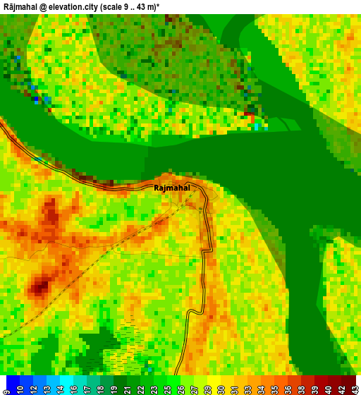
Below is the Elevation map of Rājmahal, which displays elevation range with different colors. Scale of the first map is from 9 to 43 m (30 to 141 ft) with average elevation of 27.3 meters (=90 ft) [note 1]
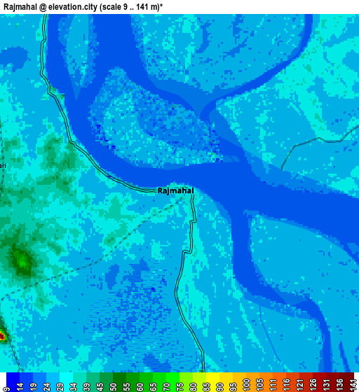
These maps also provides idea of topography and contour of this city, they are displayed at different zoom levels. More info about maps, scale and edge coordinates you can find below images.
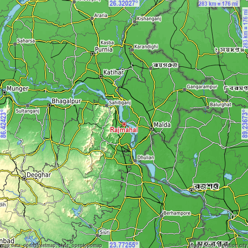
| \ | Map #1 | Map #2 | Topo.Map |
| Scale [m] | 9..43 m | 9..141 m | × |
| Scale [ft] | 30..141 ft | 30..463 ft | × |
| Average | 27.3 m = 90 ft | 28.2 m = 93 ft | × |
| Width | 8.85 km = 5.5 mi | 17.71 km = 11 mi | 283.3 km = 176 mi |
| Height | 8.85 km = 5.5 mi | 17.71 km = 11 mi | 283.3 km = 176 mi |
| ↑Max Latitude | 25.092834° | 25.132626° | 26.32027° |
| Latitude at center | 25.05303° | 25.05303° | 25.05303° |
| ↓Min Latitude | 25.013213° | 24.973383° | 23.77255° |
| ← Min Longitude | 87.786535° | 87.742589° | 86.42423° |
| Longitude center | 87.83048° | 87.83048° | 87.83048° |
| →Max Longitude | 87.874425° | 87.918371° | 89.23673° |
Nearby cities:
Cities around Rājmahal sort by population:
• Katihar elevation 34 m
60 km,  334°
334°
• Ingrāj Bāzār 32 m
32.2 km,  99°
99°
• Sāhibganj 44 m
29 km,  317°
317°
• Dhuliān 28 m
43.2 km,  163°
163°
• Pakur 47 m
46 km,  178°
178°
• Godda 102 m
67.2 km,  248°
248°
• Colgong 49 m
64.5 km,  291°
291°
• Manihāri 37 m
38.2 km, 326°
• Farakka 25 m
27.2 km,  165°
165°
• Daulatpur 37 m
58.7 km,  58°
58°
• Raghunāthpur 38 m
66.4 km,  7°
7°
• Paikpara 29 m
32.7 km, 163°
Multilingual:
 En español:
Rājmahal elevación 34 m.
 En France:
Rājmahal élévation 34 m.


Sources and notes:
- [note 1] Map square and city borders are not equal. Map elevation data is calculated only from area inside that square.
- [src 1] Elevation data from geonames database provided with same terms of usage.
- [src 2] The elevation map of Rājmahal is generated using elevation data from NASA's 3 arcsec (90m) resolution SRTM data.
- [src 3] Base (background) map © OpenStreetMap contributors tiles are generated by Geofabrik and OpenTopoMap.
Copyright & License:
This Rājmahal Elevation Map is licensed under CC BY-SA. You may reuse any part from this page, if you give a proper credit by linking to this URL:
 More info on terms of use page.