Rusera elevation
Rusera (Bihar, Samastīpur), India elevation is 52 meters and Rusera elevation in feet is 171 ft above sea level [src 1]. Rusera is a populated place (feature code) with elevation that is 241 meters (791 ft) smaller than average city elevation in India.
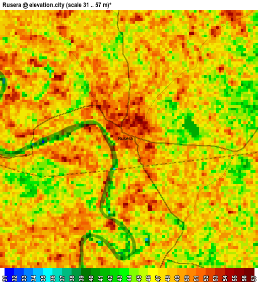
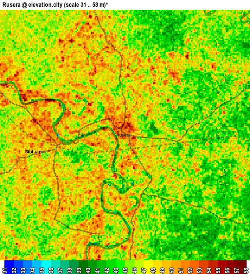
Below is the Elevation map of Rusera, which displays elevation range with different colors. Scale of the first map is from 31 to 57 m (102 to 187 ft) with average elevation of 47.1 meters (=155 ft) [note 1]
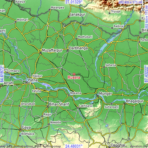
These maps also provides idea of topography and contour of this city, they are displayed at different zoom levels. More info about maps, scale and edge coordinates you can find below images.
| \ | Map #1 | Map #2 | Topo.Map |
| Scale [m] | 31..57 m | 31..58 m | × |
| Scale [ft] | 102..187 ft | 102..190 ft | × |
| Average | 47.1 m = 155 ft | 46.3 m = 152 ft | × |
| Width | 8.8 km = 5.5 mi | 17.6 km = 10.9 mi | 281.6 km = 175 mi |
| Height | 8.8 km = 5.5 mi | 17.6 km = 10.9 mi | 281.7 km = 175 mi |
| ↑Max Latitude | 25.793124° | 25.832684° | 27.01329° |
| Latitude at center | 25.75355° | 25.75355° | 25.75355° |
| ↓Min Latitude | 25.713963° | 25.674363° | 24.48031° |
| ← Min Longitude | 85.982025° | 85.938079° | 84.61972° |
| Longitude center | 86.02597° | 86.02597° | 86.02597° |
| →Max Longitude | 86.069915° | 86.113861° | 87.43222° |
Nearby cities:
Cities around Rusera sort by population:
• Darbhanga elevation 58 m
46.2 km,  343°
343°
• Begusarai 47 m
38.8 km,  163°
163°
• Bāruni 50 m
31.5 km,  190°
190°
• Bangaon 51 m
50.2 km,  75°
75°
• Samāstipur 52 m
27.5 km,  296°
296°
• Mokameh 50 m
41 km, 194°
• Khagaria 47 m
52.3 km,  122°
122°
• Bārh 52 m
43.7 km,  226°
226°
• Teghra 52 m
30.5 km,  196°
196°
• Barhiya 49 m
51.8 km,  180°
180°
• Dalsingh Sarai 52 m
21.2 km,  243°
243°
• Mohiuddinnagar 55 m
40.9 km, 240°
Multilingual:
 En español:
Rusera elevación 52 m.
 En France:
Rusera élévation 52 m.


Sources and notes:
- [note 1] Map square and city borders are not equal. Map elevation data is calculated only from area inside that square.
- [src 1] Elevation data from geonames database provided with same terms of usage.
- [src 2] The elevation map of Rusera is generated using elevation data from NASA's 3 arcsec (90m) resolution SRTM data.
- [src 3] Base (background) map © OpenStreetMap contributors tiles are generated by Geofabrik and OpenTopoMap.
Copyright & License:
This Rusera Elevation Map is licensed under CC BY-SA. You may reuse any part from this page, if you give a proper credit by linking to this URL:
 More info on terms of use page.