Sāgar elevation
Sāgar (Karnataka, Shimoga), India elevation is 592 meters and Sāgar elevation in feet is 1942 ft above sea level [src 1]. Sāgar is a populated place (feature code) with elevation that is 299 meters (981 ft) bigger than average city elevation in India.
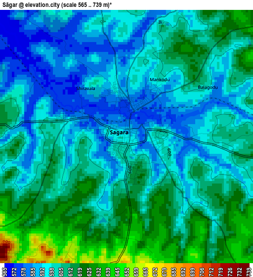
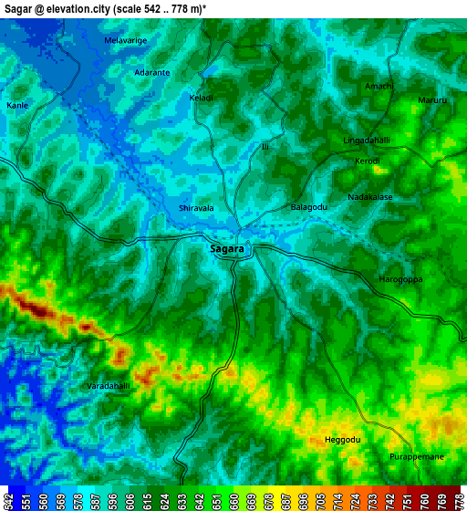
Below is the Elevation map of Sāgar, which displays elevation range with different colors. Scale of the first map is from 565 to 739 m (1854 to 2425 ft) with average elevation of 604 meters (=1982 ft) [note 1]
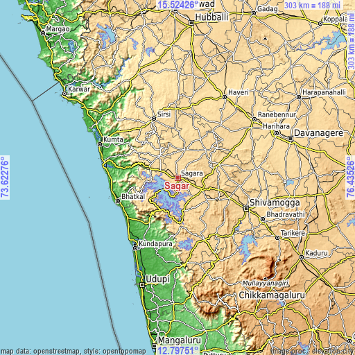
These maps also provides idea of topography and contour of this city, they are displayed at different zoom levels. More info about maps, scale and edge coordinates you can find below images.
| \ | Map #1 | Map #2 | Topo.Map |
| Scale [m] | 565..739 m | 542..778 m | × |
| Scale [ft] | 1854..2425 ft | 1778..2552 ft | × |
| Average | 604 m = 1982 ft | 612.7 m = 2010 ft | × |
| Width | 9.48 km = 5.9 mi | 18.95 km = 11.8 mi | 303.2 km = 188.4 mi |
| Height | 9.48 km = 5.9 mi | 18.95 km = 11.8 mi | 303.2 km = 188.4 mi |
| ↑Max Latitude | 14.207585° | 14.250182° | 15.52426° |
| Latitude at center | 14.16498° | 14.16498° | 14.16498° |
| ↓Min Latitude | 14.122367° | 14.079746° | 12.79751° |
| ← Min Longitude | 74.985065° | 74.941119° | 73.62276° |
| Longitude center | 75.02901° | 75.02901° | 75.02901° |
| →Max Longitude | 75.072955° | 75.116901° | 76.43526° |
Nearby cities:
Cities around Sāgar sort by population:
• Sirsi elevation 600 m
54.8 km,  337°
337°
• Shikārpur 615 m
37.2 km,  71°
71°
• Bhatkal 12 m
54.9 km,  248°
248°
• Byndoor 8 m
54.1 km,  232°
232°
• Hirekerūr 611 m
51 km,  50°
50°
• Tīrthahalli 620 m
57.9 km,  156°
156°
• Siddāpur 592 m
24.6 km,  323°
323°
• Beltangadi 652 m
35.5 km,  124°
124°
• Sorab 590 m
25 km,  15°
15°
• Kumsi 667 m
41.8 km,  107°
107°
• Hosanagara 589 m
28.2 km,  172°
172°
• Hosangadi 103 m
52.6 km,  188°
188°
Multilingual:
 En español:
Sāgar elevación 592 m.
 En France:
Sāgar élévation 592 m.


Sources and notes:
- [note 1] Map square and city borders are not equal. Map elevation data is calculated only from area inside that square.
- [src 1] Elevation data from geonames database provided with same terms of usage.
- [src 2] The elevation map of Sāgar is generated using elevation data from NASA's 3 arcsec (90m) resolution SRTM data.
- [src 3] Base (background) map © OpenStreetMap contributors tiles are generated by Geofabrik and OpenTopoMap.
Copyright & License:
This Sāgar Elevation Map is licensed under CC BY-SA. You may reuse any part from this page, if you give a proper credit by linking to this URL:
 More info on terms of use page.