Saharsa elevation
Saharsa (Bihar), India elevation is 48 meters and Saharsa elevation in feet is 157 ft above sea level [src 1]. Saharsa is a populated place (feature code) with elevation that is 245 meters (804 ft) smaller than average city elevation in India.
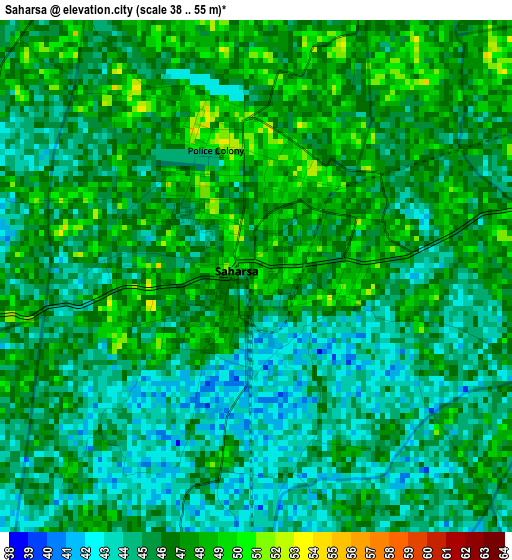
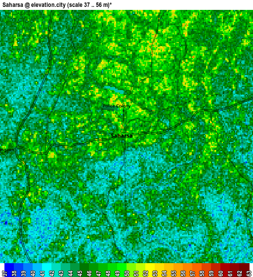
Below is the Elevation map of Saharsa, which displays elevation range with different colors. Scale of the first map is from 38 to 55 m (125 to 180 ft) with average elevation of 45.6 meters (=150 ft) [note 1]
These maps also provides idea of topography and contour of this city, they are displayed at different zoom levels. More info about maps, scale and edge coordinates you can find below images.
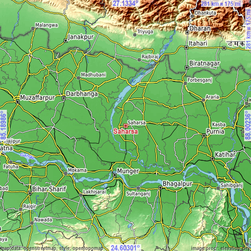
| \ | Map #1 | Map #2 | Topo.Map |
| Scale [m] | 38..55 m | 37..56 m | × |
| Scale [ft] | 125..180 ft | 121..184 ft | × |
| Average | 45.6 m = 150 ft | 45 m = 148 ft | × |
| Width | 8.79 km = 5.5 mi | 17.59 km = 10.9 mi | 281.4 km = 174.9 mi |
| Height | 8.79 km = 5.5 mi | 17.59 km = 10.9 mi | 281.4 km = 174.9 mi |
| ↑Max Latitude | 25.914513° | 25.954033° | 27.1334° |
| Latitude at center | 25.87498° | 25.87498° | 25.87498° |
| ↓Min Latitude | 25.835434° | 25.795874° | 24.60301° |
| ← Min Longitude | 86.552165° | 86.508219° | 85.18986° |
| Longitude center | 86.59611° | 86.59611° | 86.59611° |
| →Max Longitude | 86.640055° | 86.684001° | 88.00236° |
Nearby cities:
Cities around Saharsa sort by population:
• Monghyr elevation 49 m
57 km,  192°
192°
• Supaul 56 m
26.7 km,  359°
359°
• Bangaon 51 m
8.5 km,  264°
264°
• Madhipura 50 m
20.3 km,  75°
75°
• Khagaria 47 m
43.4 km,  197°
197°
• Bihārīganj 46 m
42.3 km,  111°
111°
• Jhanjhārpur 56 m
53.6 km,  323°
323°
• Rusera 52 m
58.6 km, 256°
• Banmankhi 49 m
59.9 km,  88°
88°
• Murlīganj 51 m
40.1 km, 86°
• Chhātāpur 68 m
56 km,  46°
46°
• Nirmāli 58 m
48.8 km, 358°
Multilingual:
 En español:
Saharsa elevación 48 m.
 En France:
Saharsa élévation 48 m.


Sources and notes:
- [note 1] Map square and city borders are not equal. Map elevation data is calculated only from area inside that square.
- [src 1] Elevation data from geonames database provided with same terms of usage.
- [src 2] The elevation map of Saharsa is generated using elevation data from NASA's 3 arcsec (90m) resolution SRTM data.
- [src 3] Base (background) map © OpenStreetMap contributors tiles are generated by Geofabrik and OpenTopoMap.
Copyright & License:
This Saharsa Elevation Map is licensed under CC BY-SA. You may reuse any part from this page, if you give a proper credit by linking to this URL:
 More info on terms of use page.