Sandūr elevation
Sandūr (Karnataka, Ballari), India elevation is 572 meters and Sandūr elevation in feet is 1877 ft above sea level [src 1]. Sandūr is a populated place (feature code) with elevation that is 279 meters (915 ft) bigger than average city elevation in India.
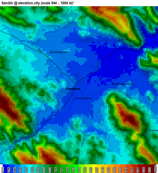
Below is the Elevation map of Sandūr, which displays elevation range with different colors. Scale of the first map is from 544 to 1004 m (1785 to 3294 ft) with average elevation of 651.1 meters (=2136 ft) [note 1]
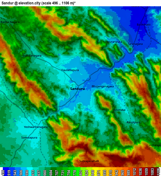
These maps also provides idea of topography and contour of this city, they are displayed at different zoom levels. More info about maps, scale and edge coordinates you can find below images.
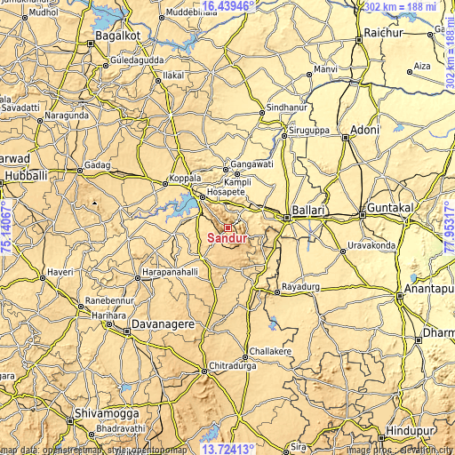
| \ | Map #1 | Map #2 | Topo.Map |
| Scale [m] | 544..1004 m | 496..1106 m | × |
| Scale [ft] | 1785..3294 ft | 1627..3629 ft | × |
| Average | 651.1 m = 2136 ft | 711.1 m = 2333 ft | × |
| Width | 9.44 km = 5.9 mi | 18.87 km = 11.7 mi | 301.9 km = 187.6 mi |
| Height | 9.44 km = 5.9 mi | 18.87 km = 11.7 mi | 301.9 km = 187.6 mi |
| ↑Max Latitude | 15.128557° | 15.170975° | 16.43946° |
| Latitude at center | 15.08613° | 15.08613° | 15.08613° |
| ↓Min Latitude | 15.043695° | 15.001252° | 13.72413° |
| ← Min Longitude | 76.502975° | 76.459029° | 75.14067° |
| Longitude center | 76.54692° | 76.54692° | 76.54692° |
| →Max Longitude | 76.590865° | 76.634811° | 77.95317° |
Nearby cities:
Cities around Sandūr sort by population:
• Bellary elevation 456 m
40.9 km,  81°
81°
• Hospet 487 m
26.6 km,  319°
319°
• Gangāwati 415 m
38.4 km,  357°
357°
• Koppal 540 m
51 km,  304°
304°
• Rāyadrug 553 m
54.1 km,  142°
142°
• Kampli 404 m
36 km,  9°
9°
• Tekkalakote 398 m
61.1 km,  35°
35°
• Hadagalli 524 m
66.4 km,  263°
263°
• Kottūru 585 m
45.6 km,  230°
230°
• Kūdligi 601 m
26.6 km,  220°
220°
• Hampi 428 m
29.2 km,  341°
341°
• Munirābād 473 m
33.4 km, 317°
Multilingual:
 En español:
Sandūr elevación 572 m.
 En France:
Sandūr élévation 572 m.


Sources and notes:
- [note 1] Map square and city borders are not equal. Map elevation data is calculated only from area inside that square.
- [src 1] Elevation data from geonames database provided with same terms of usage.
- [src 2] The elevation map of Sandūr is generated using elevation data from NASA's 3 arcsec (90m) resolution SRTM data.
- [src 3] Base (background) map © OpenStreetMap contributors tiles are generated by Geofabrik and OpenTopoMap.
Copyright & License:
This Sandūr Elevation Map is licensed under CC BY-SA. You may reuse any part from this page, if you give a proper credit by linking to this URL:
 More info on terms of use page.