Tekkalakote elevation
Tekkalakote (Karnataka, Ballari), India elevation is 398 meters and Tekkalakote elevation in feet is 1306 ft above sea level [src 1]. Tekkalakote is a populated place (feature code) with elevation that is 105 meters (344 ft) bigger than average city elevation in India.
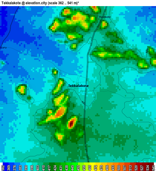
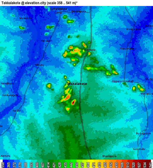
Below is the Elevation map of Tekkalakote, which displays elevation range with different colors. Scale of the first map is from 362 to 541 m (1188 to 1775 ft) with average elevation of 401.1 meters (=1316 ft) [note 1]
These maps also provides idea of topography and contour of this city, they are displayed at different zoom levels. More info about maps, scale and edge coordinates you can find below images.
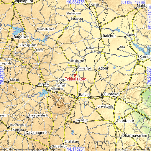
| \ | Map #1 | Map #2 | Topo.Map |
| Scale [m] | 362..541 m | 358..541 m | × |
| Scale [ft] | 1188..1775 ft | 1175..1775 ft | × |
| Average | 401.1 m = 1316 ft | 389.9 m = 1279 ft | × |
| Width | 9.42 km = 5.9 mi | 18.83 km = 11.7 mi | 301.3 km = 187.2 mi |
| Height | 9.42 km = 5.9 mi | 18.83 km = 11.7 mi | 301.3 km = 187.2 mi |
| ↑Max Latitude | 15.576776° | 15.619103° | 16.88475° |
| Latitude at center | 15.53444° | 15.53444° | 15.53444° |
| ↓Min Latitude | 15.492096° | 15.449743° | 14.17523° |
| ← Min Longitude | 76.833085° | 76.789139° | 75.47078° |
| Longitude center | 76.87703° | 76.87703° | 76.87703° |
| →Max Longitude | 76.920975° | 76.964921° | 78.28328° |
Nearby cities:
Cities around Tekkalakote sort by population:
• Bellary elevation 456 m
43.9 km,  173°
173°
• Hospet 487 m
60.2 km,  240°
240°
• Ādoni 432 m
43.9 km,  76°
76°
• Gangāwati 415 m
39 km,  252°
252°
• Sindhnūr 395 m
29.2 km,  333°
333°
• Siruguppa 375 m
10.7 km,  8°
8°
• Mānvi 375 m
54.1 km,  20°
20°
• Kampli 404 m
32.9 km, 244°
• Sandūr 572 m
61.1 km,  215°
215°
• Kosigi 386 m
53.1 km,  47°
47°
• Hampi 428 m
49.9 km, 243°
• Munirābād 473 m
62.9 km, 246°
Multilingual:
 En español:
Tekkalakote elevación 398 m.
 En France:
Tekkalakote élévation 398 m.
 Auf Deutsch:
Tekkalakote höhe über dem Meeresspiegel ist 398 m.

Sources and notes:
- [note 1] Map square and city borders are not equal. Map elevation data is calculated only from area inside that square.
- [src 1] Elevation data from geonames database provided with same terms of usage.
- [src 2] The elevation map of Tekkalakote is generated using elevation data from NASA's 3 arcsec (90m) resolution SRTM data.
- [src 3] Base (background) map © OpenStreetMap contributors tiles are generated by Geofabrik and OpenTopoMap.
Copyright & License:
This Tekkalakote Elevation Map is licensed under CC BY-SA. You may reuse any part from this page, if you give a proper credit by linking to this URL:
 More info on terms of use page.