Satara elevation
Satara (Maharashtra, Satara Division), India elevation is 709 meters and Satara elevation in feet is 2326 ft above sea level [src 1]. Satara is a populated place (feature code) with elevation that is 416 meters (1365 ft) bigger than average city elevation in India.
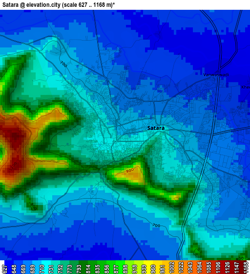
Below is the Elevation map of Satara, which displays elevation range with different colors. Scale of the first map is from 627 to 1168 m (2057 to 3832 ft) with average elevation of 719 meters (=2359 ft) [note 1]
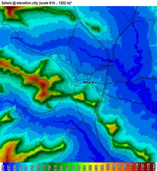
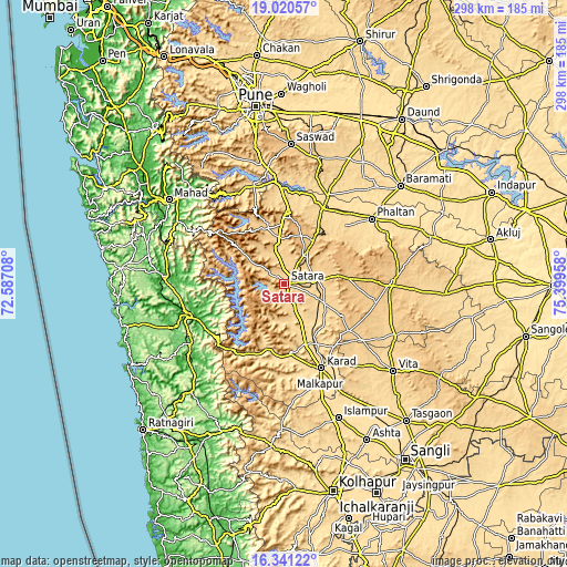
These maps also provides idea of topography and contour of this city, they are displayed at different zoom levels. More info about maps, scale and edge coordinates you can find below images.
| \ | Map #1 | Map #2 | Topo.Map |
| Scale [m] | 627..1168 m | 614..1202 m | × |
| Scale [ft] | 2057..3832 ft | 2014..3944 ft | × |
| Average | 719 m = 2359 ft | 713.6 m = 2341 ft | × |
| Width | 9.31 km = 5.8 mi | 18.62 km = 11.6 mi | 297.9 km = 185.1 mi |
| Height | 9.31 km = 5.8 mi | 18.62 km = 11.6 mi | 297.9 km = 185.1 mi |
| ↑Max Latitude | 17.727753° | 17.769607° | 19.02057° |
| Latitude at center | 17.68589° | 17.68589° | 17.68589° |
| ↓Min Latitude | 17.644017° | 17.602134° | 16.34122° |
| ← Min Longitude | 73.949385° | 73.905439° | 72.58708° |
| Longitude center | 73.99333° | 73.99333° | 73.99333° |
| →Max Longitude | 74.037275° | 74.081221° | 75.39958° |
Nearby cities:
Cities around Satara sort by population:
• Karād elevation 579 m
48.4 km,  155°
155°
• Phaltan 560 m
57.5 km,  53°
53°
• Chiplūn 14 m
54 km,  251°
251°
• Wai 710 m
31.6 km,  339°
339°
• Malkapur 579 m
50.9 km, 157°
• Koynanagar 642 m
39.8 km,  217°
217°
• Bhor 615 m
53.8 km, 342°
• Rahimatpur 649 m
24.2 km,  115°
115°
• Khed 21 m
63.3 km,  273°
273°
• Pānchgani 1263 m
33.5 km,  322°
322°
• Shirwal 594 m
51.7 km,  358°
358°
• Pātan 589 m
35.9 km,  195°
195°
Multilingual:
 En español:
Satara elevación 709 m.
 En France:
Satara élévation 709 m.


Sources and notes:
- [note 1] Map square and city borders are not equal. Map elevation data is calculated only from area inside that square.
- [src 1] Elevation data from geonames database provided with same terms of usage.
- [src 2] The elevation map of Satara is generated using elevation data from NASA's 3 arcsec (90m) resolution SRTM data.
- [src 3] Base (background) map © OpenStreetMap contributors tiles are generated by Geofabrik and OpenTopoMap.
Copyright & License:
This Satara Elevation Map is licensed under CC BY-SA. You may reuse any part from this page, if you give a proper credit by linking to this URL:
 More info on terms of use page.