Sehore elevation
Sehore (Madhya Pradesh), India elevation is 497 meters and Sehore elevation in feet is 1631 ft above sea level [src 1]. Sehore is a populated place (feature code) with elevation that is 204 meters (669 ft) bigger than average city elevation in India.
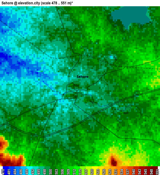
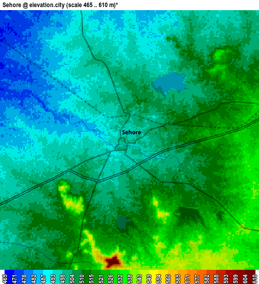
Below is the Elevation map of Sehore, which displays elevation range with different colors. Scale of the first map is from 478 to 551 m (1568 to 1808 ft) with average elevation of 501.6 meters (=1646 ft) [note 1]
These maps also provides idea of topography and contour of this city, they are displayed at different zoom levels. More info about maps, scale and edge coordinates you can find below images.
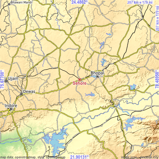
| \ | Map #1 | Map #2 | Topo.Map |
| Scale [m] | 478..551 m | 465..610 m | × |
| Scale [ft] | 1568..1808 ft | 1526..2001 ft | × |
| Average | 501.6 m = 1646 ft | 505.7 m = 1659 ft | × |
| Width | 8.98 km = 5.6 mi | 17.96 km = 11.2 mi | 287.4 km = 178.6 mi |
| Height | 8.98 km = 5.6 mi | 17.96 km = 11.2 mi | 287.4 km = 178.6 mi |
| ↑Max Latitude | 23.240386° | 23.280759° | 24.4862° |
| Latitude at center | 23.2° | 23.2° | 23.2° |
| ↓Min Latitude | 23.159602° | 23.119192° | 21.90131° |
| ← Min Longitude | 77.039385° | 76.995439° | 75.67708° |
| Longitude center | 77.08333° | 77.08333° | 77.08333° |
| →Max Longitude | 77.127275° | 77.171221° | 78.48958° |
Nearby cities:
Cities around Sehore sort by population:
• Bhopal elevation 523 m
33.2 km,  79°
79°
• Shujālpur 452 m
44.5 km,  301°
301°
• Ashta 498 m
42.1 km,  241°
241°
• Mandideep 443 m
47.8 km,  105°
105°
• Narsinghgarh 461 m
56.4 km,  1°
1°
• Berasia 483 m
59.8 km,  36°
36°
• Nasrullāhganj 301 m
60.5 km,  161°
161°
• Ichhāwar 515 m
20.3 km,  199°
199°
• Akodia 463 m
53.4 km,  292°
292°
• Rehti 308 m
62.7 km,  145°
145°
• Talen 436 m
54.8 km,  318°
318°
• Iāwar 496 m
63.2 km,  250°
250°
Multilingual:
 En español:
Sehore elevación 497 m.
 En France:
Sehore élévation 497 m.


Sources and notes:
- [note 1] Map square and city borders are not equal. Map elevation data is calculated only from area inside that square.
- [src 1] Elevation data from geonames database provided with same terms of usage.
- [src 2] The elevation map of Sehore is generated using elevation data from NASA's 3 arcsec (90m) resolution SRTM data.
- [src 3] Base (background) map © OpenStreetMap contributors tiles are generated by Geofabrik and OpenTopoMap.
Copyright & License:
This Sehore Elevation Map is licensed under CC BY-SA. You may reuse any part from this page, if you give a proper credit by linking to this URL:
 More info on terms of use page.