Siddhapur elevation
Siddhapur (Gujarat, Patan), India elevation is 140 meters and Siddhapur elevation in feet is 459 ft above sea level [src 1]. Siddhapur is a populated place (feature code) with elevation that is 153 meters (502 ft) smaller than average city elevation in India.
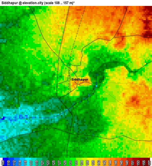
Below is the Elevation map of Siddhapur, which displays elevation range with different colors. Scale of the first map is from 108 to 157 m (354 to 515 ft) with average elevation of 131.9 meters (=433 ft) [note 1]
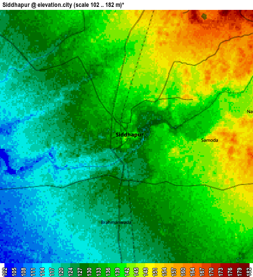
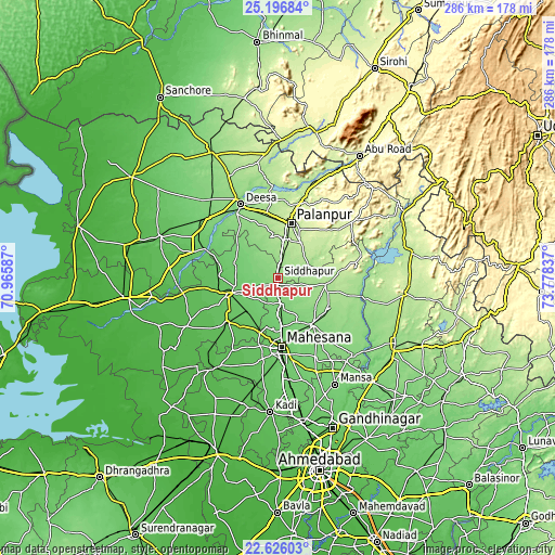
These maps also provides idea of topography and contour of this city, they are displayed at different zoom levels. More info about maps, scale and edge coordinates you can find below images.
| \ | Map #1 | Map #2 | Topo.Map |
| Scale [m] | 108..157 m | 102..182 m | × |
| Scale [ft] | 354..515 ft | 335..597 ft | × |
| Average | 131.9 m = 433 ft | 133 m = 436 ft | × |
| Width | 8.93 km = 5.5 mi | 17.87 km = 11.1 mi | 285.8 km = 177.6 mi |
| Height | 8.93 km = 5.5 mi | 17.87 km = 11.1 mi | 285.9 km = 177.6 mi |
| ↑Max Latitude | 23.957995° | 23.998148° | 25.19684° |
| Latitude at center | 23.91783° | 23.91783° | 23.91783° |
| ↓Min Latitude | 23.877652° | 23.837462° | 22.62603° |
| ← Min Longitude | 72.328175° | 72.284229° | 70.96587° |
| Longitude center | 72.37212° | 72.37212° | 72.37212° |
| →Max Longitude | 72.416065° | 72.460011° | 73.77837° |
Nearby cities:
Cities around Siddhapur sort by population:
• Pālanpur elevation 230 m
29 km,  13°
13°
• Pātan 82 m
25.8 km,  253°
253°
• Dīsa 132 m
42.4 km,  332°
332°
• Visnagar 136 m
30.5 km,  143°
143°
• Unjha 116 m
12.8 km,  171°
171°
• Un 49 m
61.3 km,  266°
266°
• Vadnagar 172 m
30.8 km,  118°
118°
• Vijāpur 126 m
55 km, 135°
• Kherālu 179 m
25.3 km,  98°
98°
• Hārij 50 m
53.5 km,  242°
242°
• Chānasma 71 m
34.7 km,  229°
229°
• Kānodar 180 m
19.2 km, 6°
Multilingual:
 En español:
Siddhapur elevación 140 m.
 En France:
Siddhapur élévation 140 m.
 Auf Deutsch:
Siddhapur höhe über dem Meeresspiegel ist 140 m.

Sources and notes:
- [note 1] Map square and city borders are not equal. Map elevation data is calculated only from area inside that square.
- [src 1] Elevation data from geonames database provided with same terms of usage.
- [src 2] The elevation map of Siddhapur is generated using elevation data from NASA's 3 arcsec (90m) resolution SRTM data.
- [src 3] Base (background) map © OpenStreetMap contributors tiles are generated by Geofabrik and OpenTopoMap.
Copyright & License:
This Siddhapur Elevation Map is licensed under CC BY-SA. You may reuse any part from this page, if you give a proper credit by linking to this URL:
 More info on terms of use page.