Sindi elevation
Sindi (Maharashtra, Wardha), India elevation is 249 meters and Sindi elevation in feet is 817 ft above sea level [src 1]. Sindi is a populated place (feature code) with elevation that is 44 meters (144 ft) smaller than average city elevation in India.
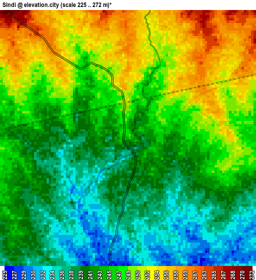
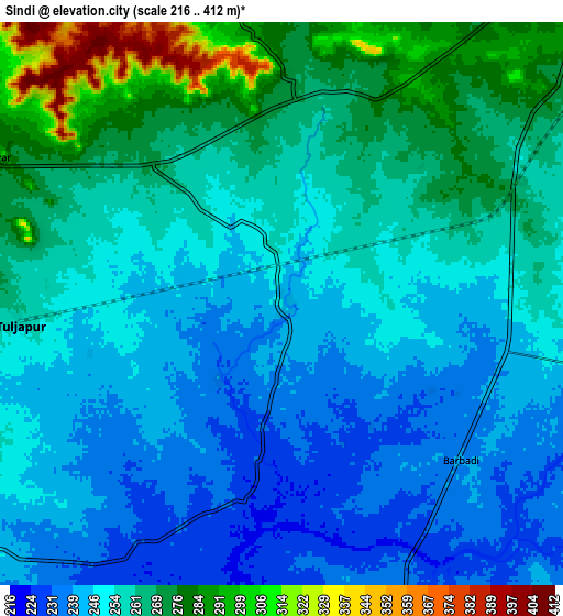
Below is the Elevation map of Sindi, which displays elevation range with different colors. Scale of the first map is from 225 to 272 m (738 to 892 ft) with average elevation of 244.9 meters (=803 ft) [note 1]
These maps also provides idea of topography and contour of this city, they are displayed at different zoom levels. More info about maps, scale and edge coordinates you can find below images.
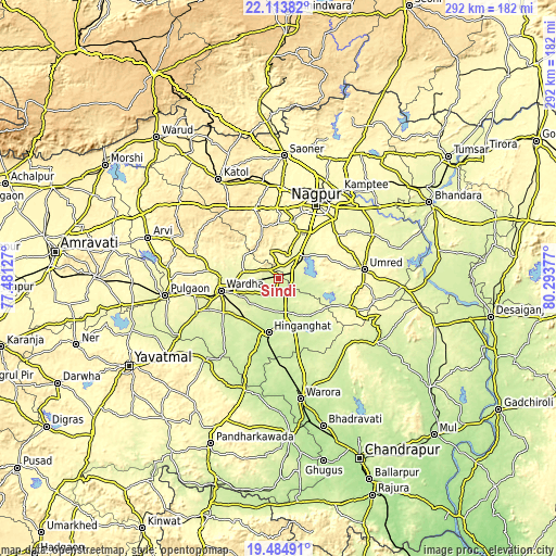
| \ | Map #1 | Map #2 | Topo.Map |
| Scale [m] | 225..272 m | 216..412 m | × |
| Scale [ft] | 738..892 ft | 709..1352 ft | × |
| Average | 244.9 m = 803 ft | 256.4 m = 841 ft | × |
| Width | 9.14 km = 5.7 mi | 18.27 km = 11.4 mi | 292.3 km = 181.6 mi |
| Height | 9.14 km = 5.7 mi | 18.27 km = 11.4 mi | 292.3 km = 181.6 mi |
| ↑Max Latitude | 20.846164° | 20.887227° | 22.11382° |
| Latitude at center | 20.80509° | 20.80509° | 20.80509° |
| ↓Min Latitude | 20.764005° | 20.722908° | 19.48491° |
| ← Min Longitude | 78.843575° | 78.799629° | 77.48127° |
| Longitude center | 78.88752° | 78.88752° | 78.88752° |
| →Max Longitude | 78.931465° | 78.975411° | 80.29377° |
Nearby cities:
Cities around Sindi sort by population:
• Nagpur elevation 319 m
43.1 km,  28°
28°
• Wardha 292 m
31 km,  256°
256°
• Hinganghāt 228 m
28.9 km,  189°
189°
• Kāmthi 288 m
55.9 km,  35°
35°
• Umred 289 m
45.8 km,  83°
83°
• Kātol 413 m
60.8 km,  329°
329°
• Pulgaon 276 m
59.7 km, 261°
• Kalmeshwar 334 m
47.6 km,  4°
4°
• Deoli 257 m
45.8 km,  247°
247°
• Sonegaon 254 m
28.2 km,  226°
226°
• Mohpa 361 m
56.5 km,  353°
353°
• Korādi 307 m
54.2 km,  24°
24°
Multilingual:
 En español:
Sindi elevación 249 m.
 En France:
Sindi élévation 249 m.


Sources and notes:
- [note 1] Map square and city borders are not equal. Map elevation data is calculated only from area inside that square.
- [src 1] Elevation data from geonames database provided with same terms of usage.
- [src 2] The elevation map of Sindi is generated using elevation data from NASA's 3 arcsec (90m) resolution SRTM data.
- [src 3] Base (background) map © OpenStreetMap contributors tiles are generated by Geofabrik and OpenTopoMap.
Copyright & License:
This Sindi Elevation Map is licensed under CC BY-SA. You may reuse any part from this page, if you give a proper credit by linking to this URL:
 More info on terms of use page.