Wardha elevation
Wardha (Maharashtra), India elevation is 292 meters and Wardha elevation in feet is 958 ft above sea level [src 1]. Wardha is a populated place (feature code) with elevation that is 1 meters (3 ft) smaller than average city elevation in India.
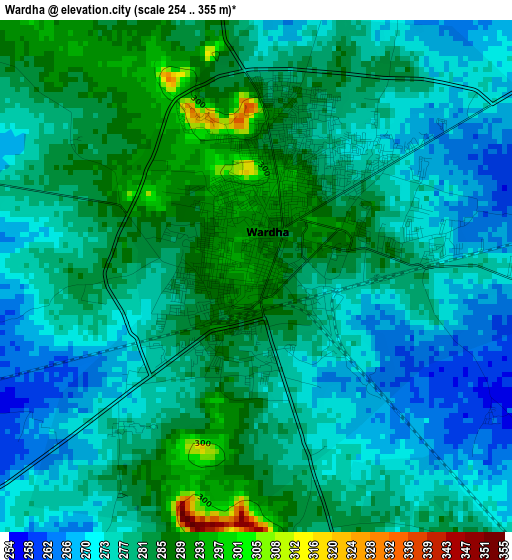
Below is the Elevation map of Wardha, which displays elevation range with different colors. Scale of the first map is from 254 to 355 m (833 to 1165 ft) with average elevation of 278.5 meters (=914 ft) [note 1]
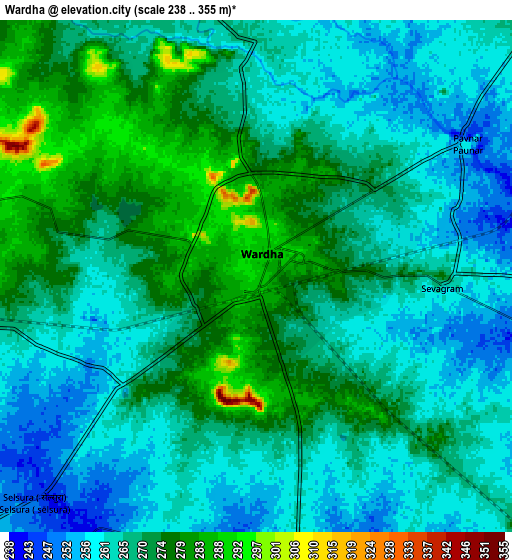
These maps also provides idea of topography and contour of this city, they are displayed at different zoom levels. More info about maps, scale and edge coordinates you can find below images.
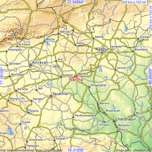
| \ | Map #1 | Map #2 | Topo.Map |
| Scale [m] | 254..355 m | 238..355 m | × |
| Scale [ft] | 833..1165 ft | 781..1165 ft | × |
| Average | 278.5 m = 914 ft | 267.2 m = 877 ft | × |
| Width | 9.14 km = 5.7 mi | 18.28 km = 11.4 mi | 292.4 km = 181.7 mi |
| Height | 9.14 km = 5.7 mi | 18.28 km = 11.4 mi | 292.5 km = 181.8 mi |
| ↑Max Latitude | 20.780422° | 20.821503° | 22.04864° |
| Latitude at center | 20.73933° | 20.73933° | 20.73933° |
| ↓Min Latitude | 20.698227° | 20.657112° | 19.41859° |
| ← Min Longitude | 78.553895° | 78.509949° | 77.19159° |
| Longitude center | 78.59784° | 78.59784° | 78.59784° |
| →Max Longitude | 78.641785° | 78.685731° | 80.00409° |
Nearby cities:
Cities around Wardha sort by population:
• Yavatmāl elevation 446 m
61.9 km,  231°
231°
• Hinganghāt 228 m
32.9 km,  130°
130°
• Kātol 413 m
59.4 km,  358°
358°
• Ārvi 307 m
47.8 km,  306°
306°
• Pulgaon 276 m
28.9 km,  266°
266°
• Dattāpur 295 m
47.8 km,  275°
275°
• Kalmeshwar 334 m
64.2 km,  31°
31°
• Chāndūr 330 m
64.7 km, 277°
• Deoli 257 m
15.8 km, 230°
• Sindi 249 m
31 km,  76°
76°
• Sonegaon 254 m
15.7 km,  141°
141°
• Mohpa 361 m
67.9 km,  20°
20°
Multilingual:
 En español:
Wardha elevación 292 m.
 En France:
Wardha élévation 292 m.


Sources and notes:
- [note 1] Map square and city borders are not equal. Map elevation data is calculated only from area inside that square.
- [src 1] Elevation data from geonames database provided with same terms of usage.
- [src 2] The elevation map of Wardha is generated using elevation data from NASA's 3 arcsec (90m) resolution SRTM data.
- [src 3] Base (background) map © OpenStreetMap contributors tiles are generated by Geofabrik and OpenTopoMap.
Copyright & License:
This Wardha Elevation Map is licensed under CC BY-SA. You may reuse any part from this page, if you give a proper credit by linking to this URL:
 More info on terms of use page.