Sri Mādhopur elevation
Sri Mādhopur (Rajasthan, Sīkar), India elevation is 502 meters and Sri Mādhopur elevation in feet is 1647 ft above sea level [src 1]. Sri Mādhopur is a populated place (feature code) with elevation that is 209 meters (686 ft) bigger than average city elevation in India.
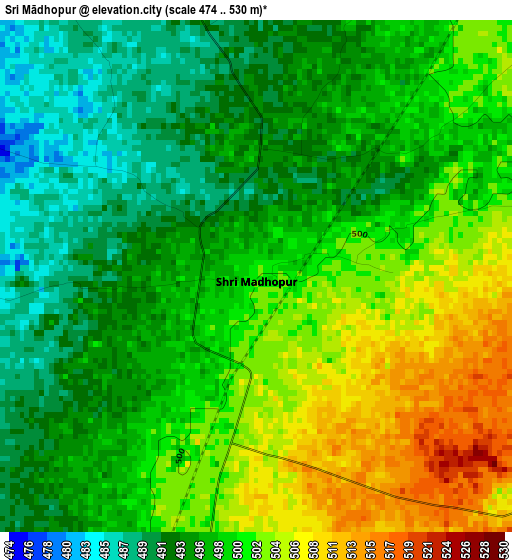
Below is the Elevation map of Sri Mādhopur, which displays elevation range with different colors. Scale of the first map is from 474 to 530 m (1555 to 1739 ft) with average elevation of 498.1 meters (=1634 ft) [note 1]
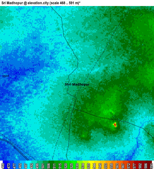
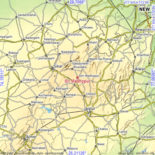
These maps also provides idea of topography and contour of this city, they are displayed at different zoom levels. More info about maps, scale and edge coordinates you can find below images.
| \ | Map #1 | Map #2 | Topo.Map |
| Scale [m] | 474..530 m | 468..591 m | × |
| Scale [ft] | 1555..1739 ft | 1535..1939 ft | × |
| Average | 498.1 m = 1634 ft | 495.2 m = 1625 ft | × |
| Width | 8.67 km = 5.4 mi | 17.34 km = 10.8 mi | 277.5 km = 172.4 mi |
| Height | 8.67 km = 5.4 mi | 17.34 km = 10.8 mi | 277.5 km = 172.4 mi |
| ↑Max Latitude | 27.504975° | 27.543946° | 28.7066° |
| Latitude at center | 27.46599° | 27.46599° | 27.46599° |
| ↓Min Latitude | 27.426991° | 27.387978° | 26.21126° |
| ← Min Longitude | 75.553415° | 75.509469° | 74.19111° |
| Longitude center | 75.59736° | 75.59736° | 75.59736° |
| →Max Longitude | 75.641305° | 75.685251° | 77.00361° |
Nearby cities:
Cities around Sri Mādhopur sort by population:
• Jaipur elevation 435 m
63.6 km,  162°
162°
• Sīkar 435 m
47.9 km,  289°
289°
• Nawalgarh 391 m
53.4 km,  323°
323°
• Shāhpura 438 m
36.7 km,  103°
103°
• Neem ka Thana 458 m
35.7 km,  31°
31°
• Udaipur 446 m
31.1 km,  336°
336°
• Rāmgarh 408 m
47.7 km,  239°
239°
• Manoharpur 456 m
39.5 km,  118°
118°
• Rīngas 475 m
11.7 km,  194°
194°
• Khandela 489 m
18.1 km,  328°
328°
• Khetri 398 m
62.3 km,  17°
17°
• Jobner 399 m
58.7 km,  200°
200°
Multilingual:
 En español:
Sri Mādhopur elevación 502 m.
 En France:
Sri Mādhopur élévation 502 m.
 Auf Deutsch:
Sri Mādhopur höhe über dem Meeresspiegel ist 502 m.

Sources and notes:
- [note 1] Map square and city borders are not equal. Map elevation data is calculated only from area inside that square.
- [src 1] Elevation data from geonames database provided with same terms of usage.
- [src 2] The elevation map of Sri Mādhopur is generated using elevation data from NASA's 3 arcsec (90m) resolution SRTM data.
- [src 3] Base (background) map © OpenStreetMap contributors tiles are generated by Geofabrik and OpenTopoMap.
Copyright & License:
This Sri Mādhopur Elevation Map is licensed under CC BY-SA. You may reuse any part from this page, if you give a proper credit by linking to this URL:
 More info on terms of use page.