Verāval elevation
Verāval (Gujarat, Gir Somnath), India elevation is 10 meters and Verāval elevation in feet is 33 ft above sea level [src 1]. Verāval is a seat of a second-order administrative division (feature code) with elevation that is 283 meters (928 ft) smaller than average city elevation in India.
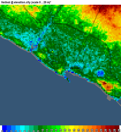
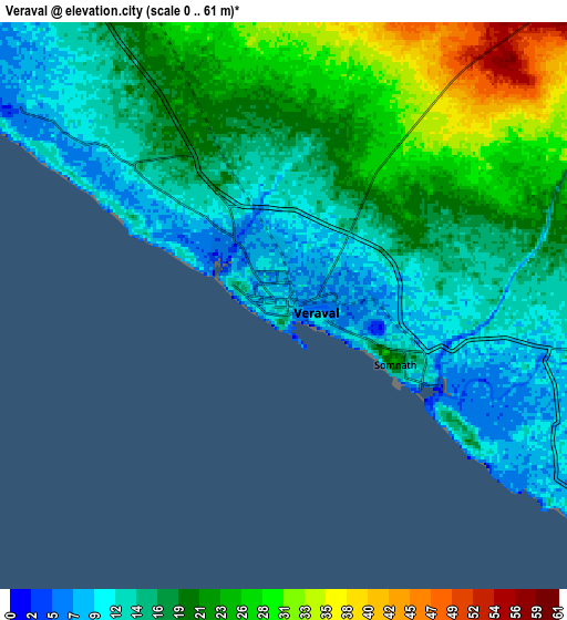
Below is the Elevation map of Verāval, which displays elevation range with different colors. Scale of the first map is from 0 to 29 m (0 to 95 ft) with average elevation of 11.4 meters (=37 ft) [note 1]
These maps also provides idea of topography and contour of this city, they are displayed at different zoom levels. More info about maps, scale and edge coordinates you can find below images.
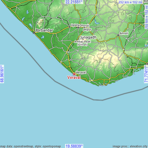
| \ | Map #1 | Map #2 | Topo.Map |
| Scale [m] | 0..29 m | 0..61 m | × |
| Scale [ft] | 0..95 ft | 0..200 ft | × |
| Average | 11.4 m = 37 ft | 18.6 m = 61 ft | × |
| Width | 9.13 km = 5.7 mi | 18.26 km = 11.3 mi | 292.1 km = 181.5 mi |
| Height | 9.13 km = 5.7 mi | 18.26 km = 11.3 mi | 292.1 km = 181.5 mi |
| ↑Max Latitude | 20.948746° | 20.989781° | 22.21551° |
| Latitude at center | 20.9077° | 20.9077° | 20.9077° |
| ↓Min Latitude | 20.866643° | 20.825574° | 19.58839° |
| ← Min Longitude | 70.323915° | 70.279969° | 68.96161° |
| Longitude center | 70.36786° | 70.36786° | 70.36786° |
| →Max Longitude | 70.411805° | 70.455751° | 71.77411° |
Nearby cities:
Cities around Verāval sort by population:
• Jūnāgadh elevation 97 m
68.7 km,  7°
7°
• Keshod 44 m
45.7 km,  344°
344°
• Māngrol 22 m
35.5 km,  312°
312°
• Una 29 m
70.3 km,  97°
97°
• Kodīnar 31 m
37 km,  110°
110°
• Mānāvadar 29 m
69.8 km, 340°
• Diu 17 m
67.4 km, 108°
• Vīsāvadar 140 m
62.2 km,  39°
39°
• Mendarda 91 m
46.6 km, 9°
• Bāntva 26 m
71.3 km,  334°
334°
• Bilkha 97 m
64.1 km,  22°
22°
• Delvāda 21 m
72 km, 101°
Multilingual:
 En español:
Verāval elevación 10 m.
 En France:
Verāval élévation 10 m.


Sources and notes:
- [note 1] Map square and city borders are not equal. Map elevation data is calculated only from area inside that square.
- [src 1] Elevation data from geonames database provided with same terms of usage.
- [src 2] The elevation map of Verāval is generated using elevation data from NASA's 3 arcsec (90m) resolution SRTM data.
- [src 3] Base (background) map © OpenStreetMap contributors tiles are generated by Geofabrik and OpenTopoMap.
Copyright & License:
This Verāval Elevation Map is licensed under CC BY-SA. You may reuse any part from this page, if you give a proper credit by linking to this URL:
 More info on terms of use page.