Yāval elevation
Yāval (Maharashtra, Jalgaon), India elevation is 215 meters and Yāval elevation in feet is 705 ft above sea level [src 1]. Yāval is a populated place (feature code) with elevation that is 78 meters (256 ft) smaller than average city elevation in India.
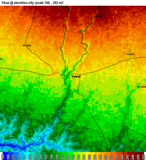
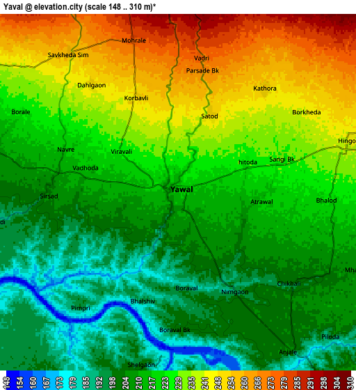
Below is the Elevation map of Yāval, which displays elevation range with different colors. Scale of the first map is from 166 to 253 m (545 to 830 ft) with average elevation of 215 meters (=705 ft) [note 1]
These maps also provides idea of topography and contour of this city, they are displayed at different zoom levels. More info about maps, scale and edge coordinates you can find below images.
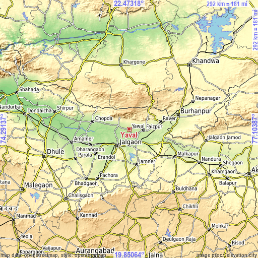
| \ | Map #1 | Map #2 | Topo.Map |
| Scale [m] | 166..253 m | 148..310 m | × |
| Scale [ft] | 545..830 ft | 486..1017 ft | × |
| Average | 215 m = 705 ft | 220.8 m = 724 ft | × |
| Width | 9.11 km = 5.7 mi | 18.23 km = 11.3 mi | 291.6 km = 181.2 mi |
| Height | 9.11 km = 5.7 mi | 18.23 km = 11.3 mi | 291.6 km = 181.2 mi |
| ↑Max Latitude | 21.208695° | 21.249658° | 22.47318° |
| Latitude at center | 21.16772° | 21.16772° | 21.16772° |
| ↓Min Latitude | 21.126734° | 21.085737° | 19.85064° |
| ← Min Longitude | 75.653675° | 75.609729° | 74.29137° |
| Longitude center | 75.69762° | 75.69762° | 75.69762° |
| →Max Longitude | 75.741565° | 75.785511° | 77.10387° |
Nearby cities:
Cities around Yāval sort by population:
• Jalgaon elevation 227 m
22.9 km,  216°
216°
• Burhānpur 251 m
57.4 km,  74°
74°
• Bhusāval 206 m
16.5 km,  146°
146°
• Chopda 195 m
42.2 km,  281°
281°
• Malkāpur 253 m
60.8 km,  121°
121°
• Varangaon 223 m
27.7 km,  127°
127°
• Dharangaon 218 m
47.2 km,  248°
248°
• Erandol 226 m
47.2 km,  234°
234°
• Rāver 255 m
36.1 km,  75°
75°
• Faizpur 227 m
16.8 km,  90°
90°
• Sāvda 224 m
20 km,  95°
95°
• Shāhpur 253 m
55.3 km, 81°
Multilingual:
 En español:
Yāval elevación 215 m.
 En France:
Yāval élévation 215 m.


Sources and notes:
- [note 1] Map square and city borders are not equal. Map elevation data is calculated only from area inside that square.
- [src 1] Elevation data from geonames database provided with same terms of usage.
- [src 2] The elevation map of Yāval is generated using elevation data from NASA's 3 arcsec (90m) resolution SRTM data.
- [src 3] Base (background) map © OpenStreetMap contributors tiles are generated by Geofabrik and OpenTopoMap.
Copyright & License:
This Yāval Elevation Map is licensed under CC BY-SA. You may reuse any part from this page, if you give a proper credit by linking to this URL:
 More info on terms of use page.