Deoli elevation
Deoli (Delhi, South Delhi), India elevation is 239 meters and Deoli elevation in feet is 784 ft above sea level [src 1]. Deoli is a populated place (feature code) with elevation that is 54 meters (177 ft) smaller than average city elevation in India.
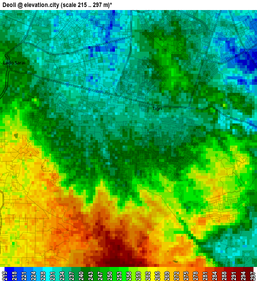
Below is the Elevation map of Deoli, which displays elevation range with different colors. Scale of the first map is from 215 to 297 m (705 to 974 ft) with average elevation of 247.9 meters (=813 ft) [note 1]
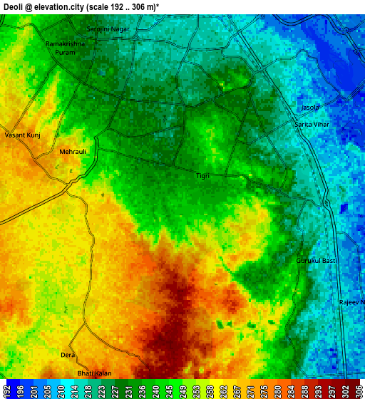
These maps also provides idea of topography and contour of this city, they are displayed at different zoom levels. More info about maps, scale and edge coordinates you can find below images.
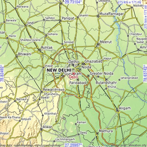
| \ | Map #1 | Map #2 | Topo.Map |
| Scale [m] | 215..297 m | 192..306 m | × |
| Scale [ft] | 705..974 ft | 630..1004 ft | × |
| Average | 247.9 m = 813 ft | 241.8 m = 793 ft | × |
| Width | 8.59 km = 5.3 mi | 17.18 km = 10.7 mi | 274.8 km = 170.8 mi |
| Height | 8.59 km = 5.3 mi | 17.18 km = 10.7 mi | 274.8 km = 170.8 mi |
| ↑Max Latitude | 28.541152° | 28.57975° | 29.73104° |
| Latitude at center | 28.50254° | 28.50254° | 28.50254° |
| ↓Min Latitude | 28.463914° | 28.425274° | 27.25957° |
| ← Min Longitude | 77.187225° | 77.143279° | 75.82492° |
| Longitude center | 77.23117° | 77.23117° | 77.23117° |
| →Max Longitude | 77.275115° | 77.319061° | 78.63742° |
Nearby cities:
Cities around Deoli sort by population:
• Delhi elevation 227 m
16.6 km,  0°
0°
• Faridabad 209 m
12.9 km,  141°
141°
• Ghāziābād 214 m
27.2 km,  48°
48°
• Karol Bāgh 231 m
17 km,  346°
346°
• New Delhi 212 m
14.8 km,  357°
357°
• Noida 206 m
12.9 km, 48°
• Gurgaon 228 m
20.6 km,  256°
256°
• Nāngloi Jāt 218 m
25.3 km,  321°
321°
• Pitampura 217 m
23 km,  334°
334°
• Sector 207 m
12 km, 50°
• Shahdara 223 m
14.3 km, 321°
• Defence Colony 214 m
7.7 km, 1°
Multilingual:
 En español:
Deoli elevación 239 m.
 En France:
Deoli élévation 239 m.


Sources and notes:
- [note 1] Map square and city borders are not equal. Map elevation data is calculated only from area inside that square.
- [src 1] Elevation data from geonames database provided with same terms of usage.
- [src 2] The elevation map of Deoli is generated using elevation data from NASA's 3 arcsec (90m) resolution SRTM data.
- [src 3] Base (background) map © OpenStreetMap contributors tiles are generated by Geofabrik and OpenTopoMap.
Copyright & License:
This Deoli Elevation Map is licensed under CC BY-SA. You may reuse any part from this page, if you give a proper credit by linking to this URL:
 More info on terms of use page.