Thurles elevation
Thurles (Munster, County Tipperary), Ireland elevation is 102 meters and Thurles elevation in feet is 335 ft above sea level [src 1]. Thurles is a populated place (feature code) with elevation that is 51 meters (167 ft) bigger than average city elevation in Ireland.
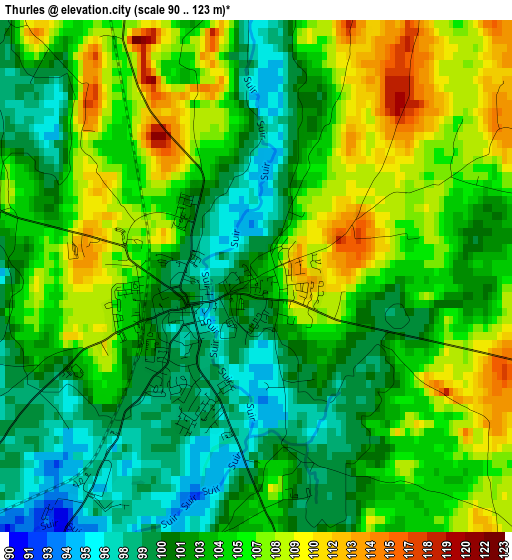
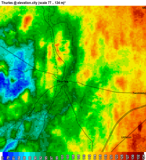
Below is the Elevation map of Thurles, which displays elevation range with different colors. Scale of the first map is from 90 to 123 m (295 to 404 ft) with average elevation of 103.9 meters (=341 ft) [note 1]
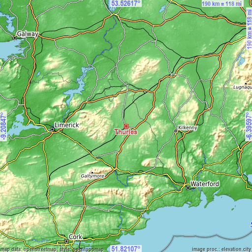
These maps also provides idea of topography and contour of this city, they are displayed at different zoom levels. More info about maps, scale and edge coordinates you can find below images.
| \ | Map #1 | Map #2 | Topo.Map |
| Scale [m] | 90..123 m | 77..134 m | × |
| Scale [ft] | 295..404 ft | 253..440 ft | × |
| Average | 103.9 m = 341 ft | 104.8 m = 344 ft | × |
| Width | 5.92 km = 3.7 mi | 11.85 km = 7.4 mi | 189.6 km = 117.8 mi |
| Height | 5.92 km = 3.7 mi | 11.85 km = 7.4 mi | 189.6 km = 117.8 mi |
| ↑Max Latitude | 52.708573° | 52.73519° | 53.52617° |
| Latitude at center | 52.68194° | 52.68194° | 52.68194° |
| ↓Min Latitude | 52.655291° | 52.628625° | 51.82107° |
| ← Min Longitude | -7.846165° | -7.890111° | -9.20847° |
| Longitude center | -7.80222° | -7.80222° | -7.80222° |
| →Max Longitude | -7.758275° | -7.714329° | -6.39597° |
Nearby cities:
Cities around Thurles sort by population:
• Cluain Meala elevation 24 m
37 km,  169°
169°
• Nenagh Bridge 52 m
34.6 km,  309°
309°
• Nenagh 52 m
33.2 km, 307°
• Roscrea 113 m
29.9 km,  0°
0°
• Tipperary 91 m
33.3 km,  225°
225°
• Cahir 56 m
34.9 km,  193°
193°
• Cashel 111 m
19.3 km,  196°
196°
• Callan 67 m
31.7 km,  118°
118°
• Templemore 114 m
12.7 km,  350°
350°
• Fethard 64 m
25 km,  162°
162°
• Rathdowney 102 m
24.3 km,  37°
37°
• Ballyragget 76 m
33.9 km,  69°
69°
Multilingual:
 En español:
Thurles elevación 102 m.
 En France:
Thurles élévation 102 m.


Sources and notes:
- [note 1] Map square and city borders are not equal. Map elevation data is calculated only from area inside that square.
- [src 1] Elevation data from geonames database provided with same terms of usage.
- [src 2] The elevation map of Thurles is generated using elevation data from NASA's 3 arcsec (90m) resolution SRTM data.
- [src 3] Base (background) map © OpenStreetMap contributors tiles are generated by Geofabrik and OpenTopoMap.
Copyright & License:
This Thurles Elevation Map is licensed under CC BY-SA. You may reuse any part from this page, if you give a proper credit by linking to this URL:
 More info on terms of use page.