Nenagh Bridge elevation
Nenagh Bridge (Munster, County Tipperary), Ireland elevation is 52 meters and Nenagh Bridge elevation in feet is 171 ft above sea level [src 1]. Nenagh Bridge is a populated place (feature code) with elevation that is 1 meters (3 ft) bigger than average city elevation in Ireland.
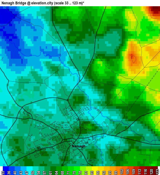
Below is the Elevation map of Nenagh Bridge, which displays elevation range with different colors. Scale of the first map is from 33 to 123 m (108 to 404 ft) with average elevation of 59.7 meters (=196 ft) [note 1]
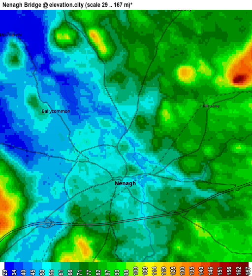
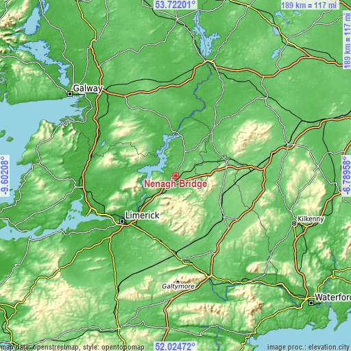
These maps also provides idea of topography and contour of this city, they are displayed at different zoom levels. More info about maps, scale and edge coordinates you can find below images.
| \ | Map #1 | Map #2 | Topo.Map |
| Scale [m] | 33..123 m | 29..167 m | × |
| Scale [ft] | 108..404 ft | 95..548 ft | × |
| Average | 59.7 m = 196 ft | 68.4 m = 224 ft | × |
| Width | 5.9 km = 3.7 mi | 11.79 km = 7.3 mi | 188.7 km = 117.3 mi |
| Height | 5.9 km = 3.7 mi | 11.79 km = 7.3 mi | 188.7 km = 117.3 mi |
| ↑Max Latitude | 52.908181° | 52.934676° | 53.72201° |
| Latitude at center | 52.88167° | 52.88167° | 52.88167° |
| ↓Min Latitude | 52.855143° | 52.828599° | 52.02472° |
| ← Min Longitude | -8.239775° | -8.283721° | -9.60208° |
| Longitude center | -8.19583° | -8.19583° | -8.19583° |
| →Max Longitude | -8.151885° | -8.107939° | -6.78958° |
Nearby cities:
Cities around Nenagh Bridge sort by population:
• Nenagh elevation 52 m
2.2 km,  181°
181°
• Roscrea 113 m
27.5 km,  73°
73°
• Birr 52 m
30 km,  39°
39°
• Annacotty 20 m
32.8 km,  223°
223°
• Ballina 41 m
18.1 km,  242°
242°
• Templemore 114 m
26.2 km,  111°
111°
• Castleconnell 26 m
27.7 km,  227°
227°
• Newport 55 m
23.8 km, 217°
• Portumna 43 m
23.1 km,  356°
356°
• Ardnacrusha 36 m
34.1 km, 235°
• Killaloe 55 m
18.6 km, 243°
• Moroe 85 m
29 km,  207°
207°
Multilingual:
 En español:
Nenagh Bridge elevación 52 m.
 En France:
Nenagh Bridge élévation 52 m.
 Auf Deutsch:
Nenagh Bridge höhe über dem Meeresspiegel ist 52 m.

Sources and notes:
- [note 1] Map square and city borders are not equal. Map elevation data is calculated only from area inside that square.
- [src 1] Elevation data from geonames database provided with same terms of usage.
- [src 2] The elevation map of Nenagh Bridge is generated using elevation data from NASA's 3 arcsec (90m) resolution SRTM data.
- [src 3] Base (background) map © OpenStreetMap contributors tiles are generated by Geofabrik and OpenTopoMap.
Copyright & License:
This Nenagh Bridge Elevation Map is licensed under CC BY-SA. You may reuse any part from this page, if you give a proper credit by linking to this URL:
 More info on terms of use page.