Besuki elevation
Besuki (East Java), Indonesia elevation is 6 meters and Besuki elevation in feet is 20 ft above sea level [src 1]. Besuki is a populated place (feature code) with elevation that is 185 meters (607 ft) smaller than average city elevation in Indonesia.
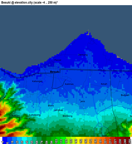
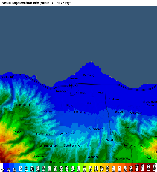
Below is the Elevation map of Besuki, which displays elevation range with different colors. Scale of the first map is from -4 to 250 m (-13 to 820 ft) with average elevation of 36.3 meters (=119 ft) [note 1]
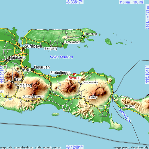
These maps also provides idea of topography and contour of this city, they are displayed at different zoom levels. More info about maps, scale and edge coordinates you can find below images.
| \ | Map #1 | Map #2 | Topo.Map |
| Scale [m] | -4..250 m | -4..1175 m | × |
| Scale [ft] | -13..820 ft | -13..3855 ft | × |
| Average | 36.3 m = 119 ft | 222.1 m = 729 ft | × |
| Width | 9.68 km = 6 mi | 19.37 km = 12 mi | 309.8 km = 192.5 mi |
| Height | 9.68 km = 6 mi | 19.37 km = 12 mi | 309.9 km = 192.6 mi |
| ↑Max Latitude | -7.690242° | -7.64669° | -6.33817° |
| Latitude at center | -7.73379° | -7.73379° | -7.73379° |
| ↓Min Latitude | -7.777333° | -7.820872° | -9.12481° |
| ← Min Longitude | 113.653905° | 113.609959° | 112.2916° |
| Longitude center | 113.69785° | 113.69785° | 113.69785° |
| →Max Longitude | 113.741795° | 113.785741° | 115.1041° |
Nearby cities:
Cities around Besuki sort by population:
• Situbondo elevation 36 m
34.5 km,  84°
84°
• Bondowoso 258 m
24.2 km,  145°
145°
• Balung 27 m
24.1 km,  89°
89°
• Panarukan 9 m
24.6 km, 81°
• Kraksaan 1 m
33.3 km,  265°
265°
• Kapongan 14 m
40.4 km, 83°
• Jelbuk 254 m
39.5 km,  170°
170°
• Sukowono 342 m
39 km,  157°
157°
• Cermee 87 m
39 km,  97°
97°
• Mangaran 17 m
38.5 km, 78°
• Kalianyar Selatan 349 m
34.5 km, 155°
• Maesan 353 m
33.4 km, 164°
Multilingual:
 En español:
Besuki elevación 6 m.
 En France:
Besuki élévation 6 m.


Sources and notes:
- [note 1] Map square and city borders are not equal. Map elevation data is calculated only from area inside that square.
- [src 1] Elevation data from geonames database provided with same terms of usage.
- [src 2] The elevation map of Besuki is generated using elevation data from NASA's 3 arcsec (90m) resolution SRTM data.
- [src 3] Base (background) map © OpenStreetMap contributors tiles are generated by Geofabrik and OpenTopoMap.
Copyright & License:
This Besuki Elevation Map is licensed under CC BY-SA. You may reuse any part from this page, if you give a proper credit by linking to this URL:
 More info on terms of use page.