Situbondo elevation
Situbondo (East Java), Indonesia elevation is 36 meters and Situbondo elevation in feet is 118 ft above sea level [src 1]. Situbondo is a seat of a second-order administrative division (feature code) with elevation that is 155 meters (509 ft) smaller than average city elevation in Indonesia.
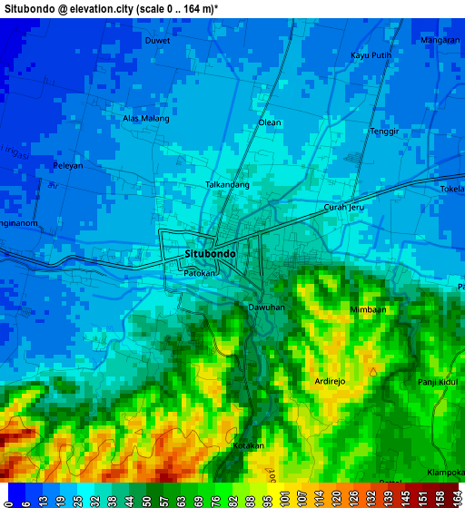
Below is the Elevation map of Situbondo, which displays elevation range with different colors. Scale of the first map is from 0 to 164 m (0 to 538 ft) with average elevation of 40.2 meters (=132 ft) [note 1]
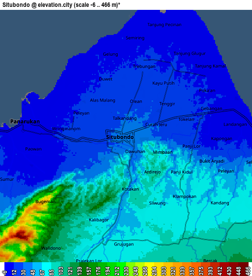
These maps also provides idea of topography and contour of this city, they are displayed at different zoom levels. More info about maps, scale and edge coordinates you can find below images.
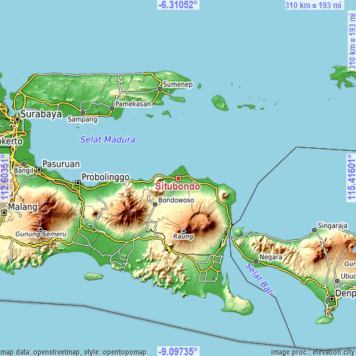
| \ | Map #1 | Map #2 | Topo.Map |
| Scale [m] | 0..164 m | -6..466 m | × |
| Scale [ft] | 0..538 ft | -20..1529 ft | × |
| Average | 40.2 m = 132 ft | 54.5 m = 179 ft | × |
| Width | 9.68 km = 6 mi | 19.37 km = 12 mi | 309.9 km = 192.6 mi |
| Height | 9.68 km = 6 mi | 19.37 km = 12 mi | 309.9 km = 192.6 mi |
| ↑Max Latitude | -7.662679° | -7.619124° | -6.31052° |
| Latitude at center | -7.70623° | -7.70623° | -7.70623° |
| ↓Min Latitude | -7.749776° | -7.793318° | -9.09735° |
| ← Min Longitude | 113.965815° | 113.921869° | 112.60351° |
| Longitude center | 114.00976° | 114.00976° | 114.00976° |
| →Max Longitude | 114.053705° | 114.097651° | 115.41601° |
Nearby cities:
Cities around Situbondo sort by population:
• Bondowoso elevation 258 m
31 km,  221°
221°
• Besuki 6 m
34.5 km,  264°
264°
• Balung 27 m
10.7 km,  253°
253°
• Panji 32 m
10.1 km,  102°
102°
• Panarukan 9 m
10.1 km,  272°
272°
• Sumberjambe 490 m
42.2 km,  196°
196°
• Kalianyar Selatan 349 m
39.7 km,  210°
210°
• Sumberanyar 34 m
33 km, 104°
• Asembagus 44 m
22.6 km, 102°
• Cermee 87 m
9 km,  151°
151°
• Kapongan 14 m
6 km,  73°
73°
• Mangaran 17 m
5.5 km,  37°
37°
Multilingual:
 En español:
Situbondo elevación 36 m.
 En France:
Situbondo élévation 36 m.
 Auf Deutsch:
Situbondo höhe über dem Meeresspiegel ist 36 m.

Sources and notes:
- [note 1] Map square and city borders are not equal. Map elevation data is calculated only from area inside that square.
- [src 1] Elevation data from geonames database provided with same terms of usage.
- [src 2] The elevation map of Situbondo is generated using elevation data from NASA's 3 arcsec (90m) resolution SRTM data.
- [src 3] Base (background) map © OpenStreetMap contributors tiles are generated by Geofabrik and OpenTopoMap.
Copyright & License:
This Situbondo Elevation Map is licensed under CC BY-SA. You may reuse any part from this page, if you give a proper credit by linking to this URL:
 More info on terms of use page.