Gongdanglegi Kulon elevation
Gongdanglegi Kulon (East Java), Indonesia elevation is 360 meters and Gongdanglegi Kulon elevation in feet is 1181 ft above sea level [src 1]. Gongdanglegi Kulon is a seat of a third-order administrative division (feature code) with elevation that is 169 meters (554 ft) bigger than average city elevation in Indonesia.
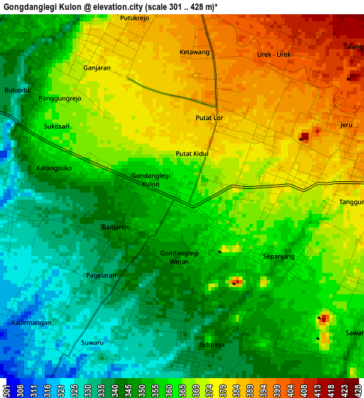
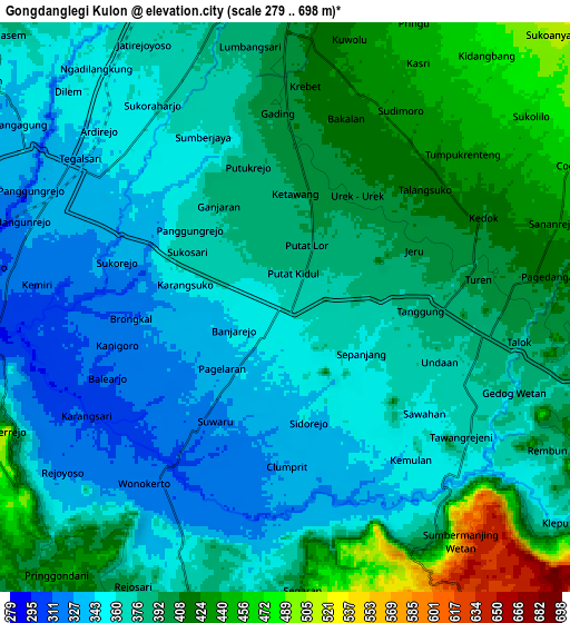
Below is the Elevation map of Gongdanglegi Kulon, which displays elevation range with different colors. Scale of the first map is from 301 to 428 m (988 to 1404 ft) with average elevation of 360.2 meters (=1182 ft) [note 1]
These maps also provides idea of topography and contour of this city, they are displayed at different zoom levels. More info about maps, scale and edge coordinates you can find below images.
| \ | Map #1 | Map #2 | Topo.Map |
| Scale [m] | 301..428 m | 279..698 m | × |
| Scale [ft] | 988..1404 ft | 915..2290 ft | × |
| Average | 360.2 m = 1182 ft | 380.7 m = 1249 ft | × |
| Width | 9.67 km = 6 mi | 19.35 km = 12 mi | 309.5 km = 192.3 mi |
| Height | 9.67 km = 6 mi | 19.35 km = 12 mi | 309.5 km = 192.3 mi |
| ↑Max Latitude | -8.131789° | -8.088283° | -6.78104° |
| Latitude at center | -8.17529° | -8.17529° | -8.17529° |
| ↓Min Latitude | -8.218786° | -8.262278° | -9.56469° |
| ← Min Longitude | 112.591995° | 112.548049° | 111.22969° |
| Longitude center | 112.63594° | 112.63594° | 112.63594° |
| →Max Longitude | 112.679885° | 112.723831° | 114.04219° |
Nearby cities:
Cities around Gongdanglegi Kulon sort by population:
• Kepanjen elevation 341 m
8.6 km,  305°
305°
• Sumberpucung 302 m
16.9 km,  276°
276°
• Pakisaji 393 m
12.8 km,  340°
340°
• Dampit 430 m
13.1 km,  107°
107°
• Kromengan 333 m
16.7 km,  287°
287°
• Bantur 301 m
16.6 km,  201°
201°
• Tajinan 469 m
14.9 km,  20°
20°
• Gedangan 512 m
13.4 km,  172°
172°
• Wajak 515 m
13.3 km,  52°
52°
• Pagak 524 m
13.2 km,  244°
244°
• Sumbermanjing Wetan 582 m
13.1 km,  153°
153°
• Turen 390 m
5.5 km,  87°
87°
Multilingual:
 En español:
Gongdanglegi Kulon elevación 360 m.
 En France:
Gongdanglegi Kulon élévation 360 m.
 Auf Deutsch:
Gongdanglegi Kulon höhe über dem Meeresspiegel ist 360 m.
 На русском:
Gongdanglegi Kulon высота над уровнем моря 360 м
Sources and notes:
- [note 1] Map square and city borders are not equal. Map elevation data is calculated only from area inside that square.
- [src 1] Elevation data from geonames database provided with same terms of usage.
- [src 2] The elevation map of Gongdanglegi Kulon is generated using elevation data from NASA's 3 arcsec (90m) resolution SRTM data.
- [src 3] Base (background) map © OpenStreetMap contributors tiles are generated by Geofabrik and OpenTopoMap.
Copyright & License:
This Gongdanglegi Kulon Elevation Map is licensed under CC BY-SA. You may reuse any part from this page, if you give a proper credit by linking to this URL:
 More info on terms of use page.