Sumberpucung elevation
Sumberpucung (East Java), Indonesia elevation is 302 meters and Sumberpucung elevation in feet is 991 ft above sea level [src 1]. Sumberpucung is a seat of a third-order administrative division (feature code) with elevation that is 111 meters (364 ft) bigger than average city elevation in Indonesia.
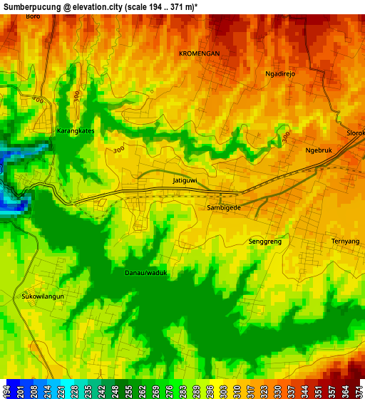
Below is the Elevation map of Sumberpucung, which displays elevation range with different colors. Scale of the first map is from 194 to 371 m (636 to 1217 ft) with average elevation of 300.5 meters (=986 ft) [note 1]
These maps also provides idea of topography and contour of this city, they are displayed at different zoom levels. More info about maps, scale and edge coordinates you can find below images.
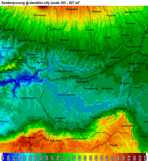
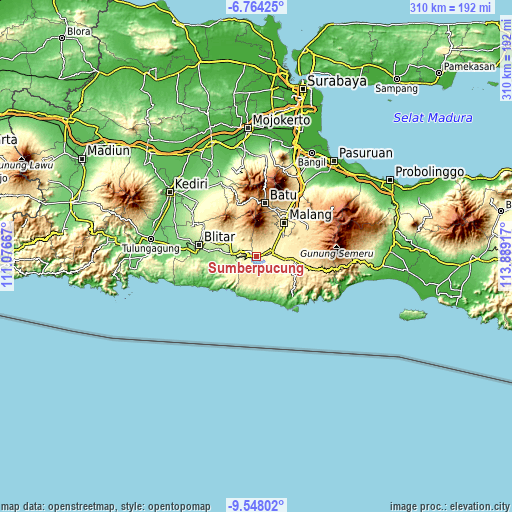
| \ | Map #1 | Map #2 | Topo.Map |
| Scale [m] | 194..371 m | 183..627 m | × |
| Scale [ft] | 636..1217 ft | 600..2057 ft | × |
| Average | 300.5 m = 986 ft | 356.1 m = 1168 ft | × |
| Width | 9.67 km = 6 mi | 19.35 km = 12 mi | 309.5 km = 192.3 mi |
| Height | 9.67 km = 6 mi | 19.35 km = 12 mi | 309.6 km = 192.4 mi |
| ↑Max Latitude | -8.115057° | -8.071549° | -6.76425° |
| Latitude at center | -8.15856° | -8.15856° | -8.15856° |
| ↓Min Latitude | -8.202058° | -8.245552° | -9.54802° |
| ← Min Longitude | 112.438975° | 112.395029° | 111.07667° |
| Longitude center | 112.48292° | 112.48292° | 112.48292° |
| →Max Longitude | 112.526865° | 112.570811° | 113.88917° |
Nearby cities:
Cities around Sumberpucung sort by population:
• Kepanjen elevation 341 m
10.4 km,  72°
72°
• Pakisaji 393 m
16.3 km,  51°
51°
• Gongdanglegi Kulon 360 m
16.9 km,  96°
96°
• Bantur 301 m
20.4 km,  148°
148°
• Wlingi 305 m
19 km,  298°
298°
• Binangun 244 m
18.2 km,  242°
242°
• Wates 423 m
15.8 km,  227°
227°
• Donomulyo 416 m
15.5 km,  203°
203°
• Kesamben 208 m
13 km,  276°
276°
• Pagak 524 m
8.9 km, 146°
• Selorejo 299 m
6.7 km,  288°
288°
• Kromengan 333 m
3.3 km,  15°
15°
Multilingual:
 En español:
Sumberpucung elevación 302 m.
 En France:
Sumberpucung élévation 302 m.
 Auf Deutsch:
Sumberpucung höhe über dem Meeresspiegel ist 302 m.

Sources and notes:
- [note 1] Map square and city borders are not equal. Map elevation data is calculated only from area inside that square.
- [src 1] Elevation data from geonames database provided with same terms of usage.
- [src 2] The elevation map of Sumberpucung is generated using elevation data from NASA's 3 arcsec (90m) resolution SRTM data.
- [src 3] Base (background) map © OpenStreetMap contributors tiles are generated by Geofabrik and OpenTopoMap.
Copyright & License:
This Sumberpucung Elevation Map is licensed under CC BY-SA. You may reuse any part from this page, if you give a proper credit by linking to this URL:
 More info on terms of use page.