Kawalu elevation
Kawalu (West Java), Indonesia elevation is 325 meters and Kawalu elevation in feet is 1066 ft above sea level [src 1]. Kawalu is a seat of a third-order administrative division (feature code) with elevation that is 134 meters (440 ft) bigger than average city elevation in Indonesia.
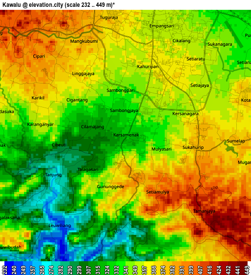
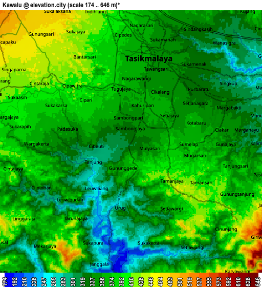
Below is the Elevation map of Kawalu, which displays elevation range with different colors. Scale of the first map is from 232 to 449 m (761 to 1473 ft) with average elevation of 349.8 meters (=1148 ft) [note 1]
These maps also provides idea of topography and contour of this city, they are displayed at different zoom levels. More info about maps, scale and edge coordinates you can find below images.
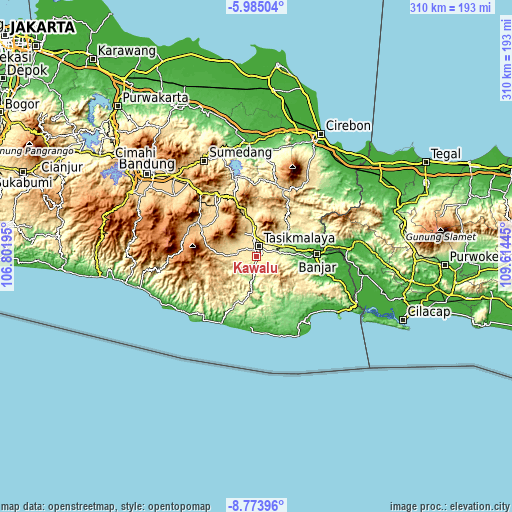
| \ | Map #1 | Map #2 | Topo.Map |
| Scale [m] | 232..449 m | 174..646 m | × |
| Scale [ft] | 761..1473 ft | 571..2119 ft | × |
| Average | 349.8 m = 1148 ft | 361.4 m = 1186 ft | × |
| Width | 9.69 km = 6 mi | 19.38 km = 12 mi | 310.1 km = 192.7 mi |
| Height | 9.69 km = 6 mi | 19.38 km = 12 mi | 310.1 km = 192.7 mi |
| ↑Max Latitude | -7.338117° | -7.294529° | -5.98504° |
| Latitude at center | -7.3817° | -7.3817° | -7.3817° |
| ↓Min Latitude | -7.425279° | -7.468854° | -8.77396° |
| ← Min Longitude | 108.164255° | 108.120309° | 106.80195° |
| Longitude center | 108.2082° | 108.2082° | 108.2082° |
| →Max Longitude | 108.252145° | 108.296091° | 109.61445° |
Nearby cities:
Cities around Kawalu sort by population:
• Tasikmalaya elevation 354 m
6.2 km,  12°
12°
• Singaparna 430 m
11.2 km,  287°
287°
• Arjasari 466 m
12.8 km, 292°
• Manonjaya 283 m
11.6 km,  72°
72°
• Sukamaju Kidul 427 m
11.2 km,  347°
347°
• Cikoneng 317 m
10.4 km,  41°
41°
• Tanjungjaya 418 m
9.6 km,  265°
265°
• Nagarasari 359 m
9.2 km, 9°
• Sukaraja 209 m
8 km,  191°
191°
• Cibeureum 338 m
7.4 km, 66°
• Argasari 368 m
6.3 km,  357°
357°
• Kahuripan 353 m
4.4 km,  29°
29°
Multilingual:
 En español:
Kawalu elevación 325 m.
 En France:
Kawalu élévation 325 m.


Sources and notes:
- [note 1] Map square and city borders are not equal. Map elevation data is calculated only from area inside that square.
- [src 1] Elevation data from geonames database provided with same terms of usage.
- [src 2] The elevation map of Kawalu is generated using elevation data from NASA's 3 arcsec (90m) resolution SRTM data.
- [src 3] Base (background) map © OpenStreetMap contributors tiles are generated by Geofabrik and OpenTopoMap.
Copyright & License:
This Kawalu Elevation Map is licensed under CC BY-SA. You may reuse any part from this page, if you give a proper credit by linking to this URL:
 More info on terms of use page.