Sukaraja elevation
Sukaraja (West Java), Indonesia elevation is 209 meters and Sukaraja elevation in feet is 686 ft above sea level [src 1]. Sukaraja is a seat of a third-order administrative division (feature code) with elevation that is 18 meters (59 ft) bigger than average city elevation in Indonesia.
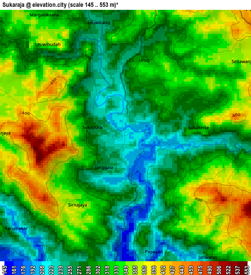
Below is the Elevation map of Sukaraja, which displays elevation range with different colors. Scale of the first map is from 145 to 553 m (476 to 1814 ft) with average elevation of 311.6 meters (=1022 ft) [note 1]
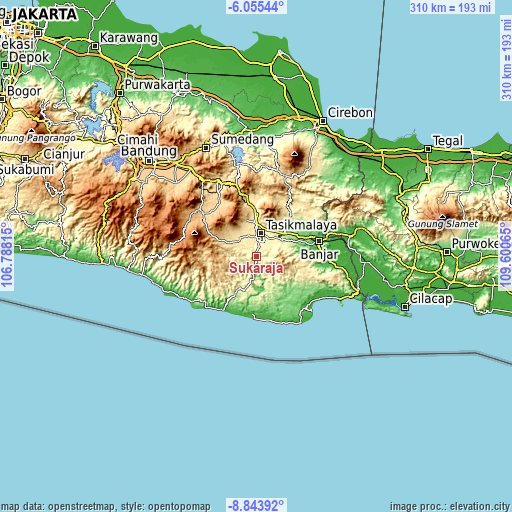
These maps also provides idea of topography and contour of this city, they are displayed at different zoom levels. More info about maps, scale and edge coordinates you can find below images.
| \ | Map #1 | Topo.Map |
| Scale [m] | 145..553 m | × |
| Scale [ft] | 476..1814 ft | × |
| Average | 311.6 m = 1022 ft | × |
| Width | 9.69 km = 6 mi | 310 km = 192.6 mi |
| Height | 9.69 km = 6 mi | 310.1 km = 192.7 mi |
| ↑Max Latitude | -7.408324° | -6.05544° |
| Latitude at center | -7.4519° | -7.4519° |
| ↓Min Latitude | -7.495472° | -8.84392° |
| ← Min Longitude | 108.150455° | 106.78815° |
| Longitude center | 108.1944° | 108.1944° |
| →Max Longitude | 108.238345° | 109.60065° |
Nearby cities:
Cities around Sukaraja sort by population:
• Tasikmalaya elevation 354 m
14.1 km,  11°
11°
• Kawalu 325 m
8 km, 11°
• Singaparna 430 m
14.5 km,  320°
320°
• Manonjaya 283 m
16.9 km,  48°
48°
• Arjasari 466 m
16.4 km, 321°
• Sodong Hilir 706 m
16.3 km,  255°
255°
• Argasari 368 m
14.2 km, 5°
• Cibeureum 338 m
13.6 km,  37°
37°
• Kahuripan 353 m
12.2 km,  17°
17°
• Salopa 292 m
11.2 km,  129°
129°
• Tanjungjaya 418 m
10.7 km,  311°
311°
• Cibalong 162 m
7.1 km,  191°
191°
Multilingual:
 En español:
Sukaraja elevación 209 m.
 En France:
Sukaraja élévation 209 m.
 Auf Deutsch:
Sukaraja höhe über dem Meeresspiegel ist 209 m.

Sources and notes:
- [note 1] Map square and city borders are not equal. Map elevation data is calculated only from area inside that square.
- [src 1] Elevation data from geonames database provided with same terms of usage.
- [src 2] The elevation map of Sukaraja is generated using elevation data from NASA's 3 arcsec (90m) resolution SRTM data.
- [src 3] Base (background) map © OpenStreetMap contributors tiles are generated by Geofabrik and OpenTopoMap.
Copyright & License:
This Sukaraja Elevation Map is licensed under CC BY-SA. You may reuse any part from this page, if you give a proper credit by linking to this URL:
 More info on terms of use page.