Ketanggungan elevation
Ketanggungan (Central Java), Indonesia elevation is 16 meters and Ketanggungan elevation in feet is 52 ft above sea level [src 1]. Ketanggungan is a populated place (feature code) with elevation that is 175 meters (574 ft) smaller than average city elevation in Indonesia.
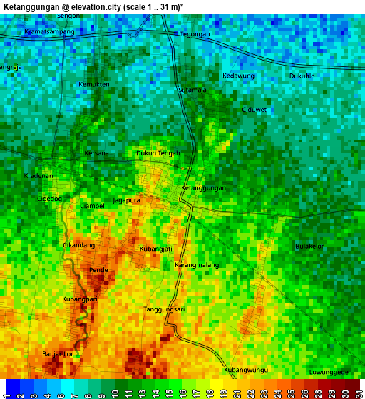
Below is the Elevation map of Ketanggungan, which displays elevation range with different colors. Scale of the first map is from 1 to 31 m (3 to 102 ft) with average elevation of 13.2 meters (=43 ft) [note 1]
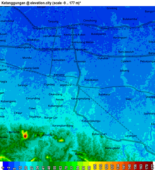
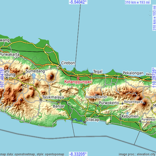
These maps also provides idea of topography and contour of this city, they are displayed at different zoom levels. More info about maps, scale and edge coordinates you can find below images.
| \ | Map #1 | Map #2 | Topo.Map |
| Scale [m] | 1..31 m | -9..177 m | × |
| Scale [ft] | 3..102 ft | -30..581 ft | × |
| Average | 13.2 m = 43 ft | 15.9 m = 52 ft | × |
| Width | 9.7 km = 6 mi | 19.4 km = 12.1 mi | 310.4 km = 192.9 mi |
| Height | 9.7 km = 6 mi | 19.4 km = 12.1 mi | 310.4 km = 192.9 mi |
| ↑Max Latitude | -6.894674° | -6.851045° | -5.54042° |
| Latitude at center | -6.9383° | -6.9383° | -6.9383° |
| ↓Min Latitude | -6.981921° | -7.025539° | -8.33205° |
| ← Min Longitude | 108.847055° | 108.803109° | 107.48475° |
| Longitude center | 108.891° | 108.891° | 108.891° |
| →Max Longitude | 108.934945° | 108.978891° | 110.29725° |
Nearby cities:
Cities around Ketanggungan sort by population:
• Tegal elevation 7 m
28.6 km,  74°
74°
• Adiwerna 23 m
26.7 km,  89°
89°
• Dukuhturi 4 m
21.7 km,  78°
78°
• Karangsembung 14 m
29.2 km,  289°
289°
• Slawi 43 m
28 km,  99°
99°
• Balapulang 128 m
26.2 km,  117°
117°
• Margasari 46 m
22.7 km,  142°
142°
• Bulakamba 5 m
10.1 km,  45°
45°
• Luragung 113 m
29.3 km,  252°
252°
• Salem 316 m
28.7 km,  199°
199°
• Cibingbin 79 m
19.7 km,  226°
226°
• Brebes 8 m
17.9 km,  64°
64°
Multilingual:
 En español:
Ketanggungan elevación 16 m.
 En France:
Ketanggungan élévation 16 m.
 Auf Deutsch:
Ketanggungan höhe über dem Meeresspiegel ist 16 m.

Sources and notes:
- [note 1] Map square and city borders are not equal. Map elevation data is calculated only from area inside that square.
- [src 1] Elevation data from geonames database provided with same terms of usage.
- [src 2] The elevation map of Ketanggungan is generated using elevation data from NASA's 3 arcsec (90m) resolution SRTM data.
- [src 3] Base (background) map © OpenStreetMap contributors tiles are generated by Geofabrik and OpenTopoMap.
Copyright & License:
This Ketanggungan Elevation Map is licensed under CC BY-SA. You may reuse any part from this page, if you give a proper credit by linking to this URL:
 More info on terms of use page.