Salem elevation
Salem (Central Java), Indonesia elevation is 316 meters and Salem elevation in feet is 1037 ft above sea level [src 1]. Salem is a seat of a third-order administrative division (feature code) with elevation that is 125 meters (410 ft) bigger than average city elevation in Indonesia.
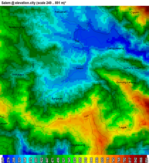
Below is the Elevation map of Salem, which displays elevation range with different colors. Scale of the first map is from 249 to 891 m (817 to 2923 ft) with average elevation of 463.9 meters (=1522 ft) [note 1]
These maps also provides idea of topography and contour of this city, they are displayed at different zoom levels. More info about maps, scale and edge coordinates you can find below images.
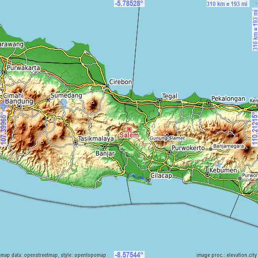
| \ | Map #1 | Topo.Map |
| Scale [m] | 249..891 m | × |
| Scale [ft] | 817..2923 ft | × |
| Average | 463.9 m = 1522 ft | × |
| Width | 9.7 km = 6 mi | 310.2 km = 192.7 mi |
| Height | 9.7 km = 6 mi | 310.3 km = 192.8 mi |
| ↑Max Latitude | -7.138897° | -5.78528° |
| Latitude at center | -7.1825° | -7.1825° |
| ↓Min Latitude | -7.226098° | -8.57544° |
| ← Min Longitude | 108.761955° | 107.39965° |
| Longitude center | 108.8059° | 108.8059° |
| →Max Longitude | 108.849845° | 110.21215° |
Nearby cities:
Cities around Salem sort by population:
• Ketanggungan elevation 16 m
28.7 km,  19°
19°
• Majenang 40 m
13.6 km,  199°
199°
• Margasari 46 m
25 km,  68°
68°
• Lebakwangi 134 m
29.1 km,  309°
309°
• Cipari 17 m
28.9 km,  189°
189°
• Sinargalih 19 m
26.8 km,  223°
223°
• Luragung 113 m
26.1 km, 314°
• Dayeuhluhur 202 m
23.2 km,  248°
248°
• Ciwaru 166 m
22.8 km,  300°
300°
• Wanareja 37 m
21.2 km, 217°
• Cimanggu 43 m
19.3 km,  168°
168°
• Cibingbin 79 m
14.3 km,  340°
340°
Multilingual:
 En español:
Salem elevación 316 m.
 En France:
Salem élévation 316 m.


Sources and notes:
- [note 1] Map square and city borders are not equal. Map elevation data is calculated only from area inside that square.
- [src 1] Elevation data from geonames database provided with same terms of usage.
- [src 2] The elevation map of Salem is generated using elevation data from NASA's 3 arcsec (90m) resolution SRTM data.
- [src 3] Base (background) map © OpenStreetMap contributors tiles are generated by Geofabrik and OpenTopoMap.
Copyright & License:
This Salem Elevation Map is licensed under CC BY-SA. You may reuse any part from this page, if you give a proper credit by linking to this URL:
 More info on terms of use page.