Kokas Kota elevation
Kokas Kota (West Papua), Indonesia elevation is 12 meters and Kokas Kota elevation in feet is 39 ft above sea level [src 1]. Kokas Kota is a seat of a third-order administrative division (feature code) with elevation that is 179 meters (587 ft) smaller than average city elevation in Indonesia.
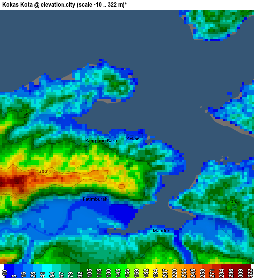
Below is the Elevation map of Kokas Kota, which displays elevation range with different colors. Scale of the first map is from -10 to 322 m (-33 to 1056 ft) with average elevation of 79.2 meters (=260 ft) [note 1]
These maps also provides idea of topography and contour of this city, they are displayed at different zoom levels. More info about maps, scale and edge coordinates you can find below images.
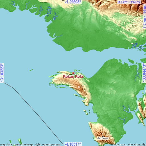
| \ | Map #1 | Topo.Map |
| Scale [m] | -10..322 m | × |
| Scale [ft] | -33..1056 ft | × |
| Average | 79.2 m = 260 ft | × |
| Width | 9.76 km = 6.1 mi | 312.3 km = 194.1 mi |
| Height | 9.76 km = 6.1 mi | 312.4 km = 194.1 mi |
| ↑Max Latitude | -2.657543° | -1.29608° |
| Latitude at center | -2.70144° | -2.70144° |
| ↓Min Latitude | -2.745336° | -4.10517° |
| ← Min Longitude | 132.394535° | 131.03223° |
| Longitude center | 132.43848° | 132.43848° |
| →Max Longitude | 132.482425° | 133.84473° |
Nearby cities:
Cities around Kokas Kota sort by population:
• Aitinyo elevation 323 m
154.9 km,  356°
356°
• Merdey 189 m
153.5 km,  41°
41°
• Bofuer 29 m
151 km,  103°
103°
• Teminabuan 35 m
147.8 km,  341°
341°
• Bintuni 95 m
138.7 km,  61°
61°
• Babo 20 m
110.5 km,  80°
80°
• Serkos 1 m
70.8 km,  334°
334°
• Patipi Pasir 1 m
34.6 km,  268°
268°
• Dulanpokpok 69 m
31.1 km,  216°
216°
• Fakfak 71 m
29.3 km,  212°
212°
• Raduria 146 m
28.8 km,  203°
203°
• Kramongmongga 223 m
9.1 km, 224°
Multilingual:
 En español:
Kokas Kota elevación 12 m.
 En France:
Kokas Kota élévation 12 m.
 Auf Deutsch:
Kokas Kota höhe über dem Meeresspiegel ist 12 m.

Sources and notes:
- [note 1] Map square and city borders are not equal. Map elevation data is calculated only from area inside that square.
- [src 1] Elevation data from geonames database provided with same terms of usage.
- [src 2] The elevation map of Kokas Kota is generated using elevation data from NASA's 3 arcsec (90m) resolution SRTM data.
- [src 3] Base (background) map © OpenStreetMap contributors tiles are generated by Geofabrik and OpenTopoMap.
Copyright & License:
This Kokas Kota Elevation Map is licensed under CC BY-SA. You may reuse any part from this page, if you give a proper credit by linking to this URL:
 More info on terms of use page.