Aitinyo elevation
Aitinyo (West Papua), Indonesia elevation is 323 meters and Aitinyo elevation in feet is 1060 ft above sea level [src 1]. Aitinyo is a seat of a third-order administrative division (feature code) with elevation that is 132 meters (433 ft) bigger than average city elevation in Indonesia.
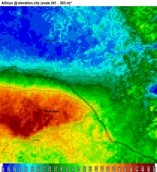
Below is the Elevation map of Aitinyo, which displays elevation range with different colors. Scale of the first map is from 241 to 503 m (791 to 1650 ft) with average elevation of 339.4 meters (=1114 ft) [note 1]
These maps also provides idea of topography and contour of this city, they are displayed at different zoom levels. More info about maps, scale and edge coordinates you can find below images.
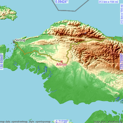
| \ | Map #1 | Topo.Map |
| Scale [m] | 241..503 m | × |
| Scale [ft] | 791..1650 ft | × |
| Average | 339.4 m = 1114 ft | × |
| Width | 9.77 km = 6.1 mi | 312.6 km = 194.2 mi |
| Height | 9.77 km = 6.1 mi | 312.6 km = 194.2 mi |
| ↑Max Latitude | -1.267966° | 0.09424° |
| Latitude at center | -1.3119° | -1.3119° |
| ↓Min Latitude | -1.355833° | -2.71725° |
| ← Min Longitude | 132.300755° | 130.93845° |
| Longitude center | 132.3447° | 132.3447° |
| →Max Longitude | 132.388645° | 133.75095° |
Nearby cities:
Cities around Aitinyo sort by population:
• Merdey elevation 189 m
118.2 km,  109°
109°
• Makbon 5 m
109.4 km,  305°
305°
• Kebar 584 m
102.9 km,  59°
59°
• Sausapor 13 m
94.8 km,  342°
342°
• Serkos 1 m
92.6 km,  192°
192°
• Mega 9 m
87.1 km,  325°
325°
• Wanurian 15 m
86.8 km,  274°
274°
• Fef 426 m
56.8 km,  9°
9°
• Teminabuan 35 m
39.5 km,  248°
248°
• Aifat 511 m
23.8 km,  47°
47°
• Kumurkek 446 m
18.3 km,  70°
70°
• Ayamaru 286 m
17.3 km,  283°
283°
Multilingual:
 En español:
Aitinyo elevación 323 m.
 En France:
Aitinyo élévation 323 m.


Sources and notes:
- [note 1] Map square and city borders are not equal. Map elevation data is calculated only from area inside that square.
- [src 1] Elevation data from geonames database provided with same terms of usage.
- [src 2] The elevation map of Aitinyo is generated using elevation data from NASA's 3 arcsec (90m) resolution SRTM data.
- [src 3] Base (background) map © OpenStreetMap contributors tiles are generated by Geofabrik and OpenTopoMap.
Copyright & License:
This Aitinyo Elevation Map is licensed under CC BY-SA. You may reuse any part from this page, if you give a proper credit by linking to this URL:
 More info on terms of use page.