Kuningan elevation
Kuningan (West Java), Indonesia elevation is 537 meters and Kuningan elevation in feet is 1762 ft above sea level [src 1]. Kuningan is a seat of a second-order administrative division (feature code) with elevation that is 346 meters (1135 ft) bigger than average city elevation in Indonesia.
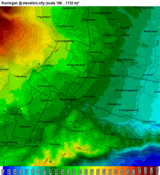
Below is the Elevation map of Kuningan, which displays elevation range with different colors. Scale of the first map is from 186 to 1132 m (610 to 3714 ft) with average elevation of 555.1 meters (=1821 ft) [note 1]
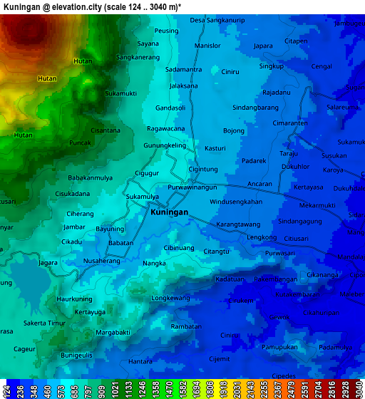
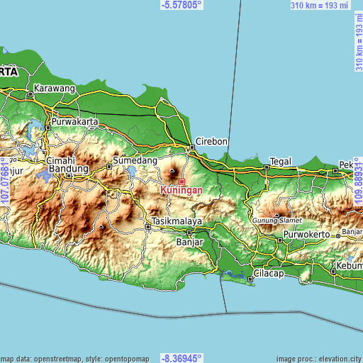
These maps also provides idea of topography and contour of this city, they are displayed at different zoom levels. More info about maps, scale and edge coordinates you can find below images.
| \ | Map #1 | Map #2 | Topo.Map |
| Scale [m] | 186..1132 m | 124..3040 m | × |
| Scale [ft] | 610..3714 ft | 407..9974 ft | × |
| Average | 555.1 m = 1821 ft | 641.2 m = 2104 ft | × |
| Width | 9.7 km = 6 mi | 19.4 km = 12.1 mi | 310.4 km = 192.9 mi |
| Height | 9.7 km = 6 mi | 19.4 km = 12.1 mi | 310.4 km = 192.9 mi |
| ↑Max Latitude | -6.932208° | -6.888582° | -5.57805° |
| Latitude at center | -6.97583° | -6.97583° | -6.97583° |
| ↓Min Latitude | -7.019448° | -7.063062° | -8.36945° |
| ← Min Longitude | 108.439115° | 108.395169° | 107.07681° |
| Longitude center | 108.48306° | 108.48306° | 108.48306° |
| →Max Longitude | 108.527005° | 108.570951° | 109.88931° |
Nearby cities:
Cities around Kuningan sort by population:
• Karangsembung elevation 14 m
22.5 km,  51°
51°
• Rajadesa 435 m
23.7 km,  193°
193°
• Ciwaru 166 m
19.6 km,  125°
125°
• Panawangan 683 m
19.4 km,  215°
215°
• Luragung 113 m
17.7 km,  105°
105°
• Subang 309 m
17.6 km,  163°
163°
• Selajambe 305 m
16 km, 188°
• Lebakwangi 134 m
13.9 km, 109°
• Cikijing 602 m
13.6 km,  250°
250°
• Darma 724 m
9.3 km, 250°
• Garawangi 292 m
6.7 km, 112°
• Kadugede 518 m
4.5 km,  225°
225°
Multilingual:
 En español:
Kuningan elevación 537 m.
 En France:
Kuningan élévation 537 m.
 Auf Deutsch:
Kuningan höhe über dem Meeresspiegel ist 537 m.

Sources and notes:
- [note 1] Map square and city borders are not equal. Map elevation data is calculated only from area inside that square.
- [src 1] Elevation data from geonames database provided with same terms of usage.
- [src 2] The elevation map of Kuningan is generated using elevation data from NASA's 3 arcsec (90m) resolution SRTM data.
- [src 3] Base (background) map © OpenStreetMap contributors tiles are generated by Geofabrik and OpenTopoMap.
Copyright & License:
This Kuningan Elevation Map is licensed under CC BY-SA. You may reuse any part from this page, if you give a proper credit by linking to this URL:
 More info on terms of use page.