Rajadesa elevation
Rajadesa (West Java), Indonesia elevation is 435 meters and Rajadesa elevation in feet is 1427 ft above sea level [src 1]. Rajadesa is a seat of a third-order administrative division (feature code) with elevation that is 244 meters (801 ft) bigger than average city elevation in Indonesia.
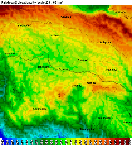
Below is the Elevation map of Rajadesa, which displays elevation range with different colors. Scale of the first map is from 229 to 631 m (751 to 2070 ft) with average elevation of 449.6 meters (=1475 ft) [note 1]
These maps also provides idea of topography and contour of this city, they are displayed at different zoom levels. More info about maps, scale and edge coordinates you can find below images.
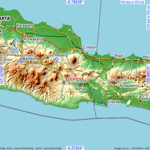
| \ | Map #1 | Topo.Map |
| Scale [m] | 229..631 m | × |
| Scale [ft] | 751..2070 ft | × |
| Average | 449.6 m = 1475 ft | × |
| Width | 9.7 km = 6 mi | 310.2 km = 192.7 mi |
| Height | 9.7 km = 6 mi | 310.3 km = 192.8 mi |
| ↑Max Latitude | -7.139998° | -5.78638° |
| Latitude at center | -7.1836° | -7.1836° |
| ↓Min Latitude | -7.227198° | -8.57654° |
| ← Min Longitude | 108.390155° | 107.02785° |
| Longitude center | 108.4341° | 108.4341° |
| →Max Longitude | 108.478045° | 109.84035° |
Nearby cities:
Cities around Rajadesa sort by population:
• Ciamis elevation 207 m
18.1 km,  209°
209°
• Cijeungjing 135 m
16.7 km,  187°
187°
• Sadananya 388 m
16.6 km,  232°
232°
• Tambaksari 361 m
13.3 km,  123°
123°
• Subang 309 m
12.1 km,  59°
59°
• Panawangan 683 m
9.3 km,  321°
321°
• Sukadana 203 m
9.1 km,  175°
175°
• Buniseuri 301 m
9 km,  223°
223°
• Rancah 349 m
7.9 km,  100°
100°
• Selajambe 305 m
7.9 km,  23°
23°
• Kawali 384 m
7 km,  268°
268°
• Jatinagara 438 m
3.6 km,  288°
288°
Multilingual:
 En español:
Rajadesa elevación 435 m.
 En France:
Rajadesa élévation 435 m.
 Auf Deutsch:
Rajadesa höhe über dem Meeresspiegel ist 435 m.

Sources and notes:
- [note 1] Map square and city borders are not equal. Map elevation data is calculated only from area inside that square.
- [src 1] Elevation data from geonames database provided with same terms of usage.
- [src 2] The elevation map of Rajadesa is generated using elevation data from NASA's 3 arcsec (90m) resolution SRTM data.
- [src 3] Base (background) map © OpenStreetMap contributors tiles are generated by Geofabrik and OpenTopoMap.
Copyright & License:
This Rajadesa Elevation Map is licensed under CC BY-SA. You may reuse any part from this page, if you give a proper credit by linking to this URL:
 More info on terms of use page.