Tambaksari elevation
Tambaksari (West Java), Indonesia elevation is 361 meters and Tambaksari elevation in feet is 1184 ft above sea level [src 1]. Tambaksari is a seat of a third-order administrative division (feature code) with elevation that is 170 meters (558 ft) bigger than average city elevation in Indonesia.
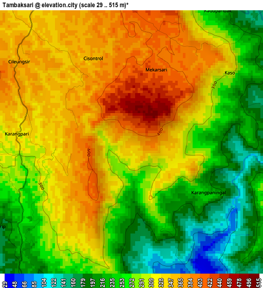
Below is the Elevation map of Tambaksari, which displays elevation range with different colors. Scale of the first map is from 29 to 515 m (95 to 1690 ft) with average elevation of 295.9 meters (=971 ft) [note 1]
These maps also provides idea of topography and contour of this city, they are displayed at different zoom levels. More info about maps, scale and edge coordinates you can find below images.
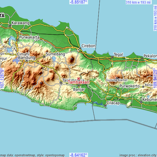
| \ | Map #1 | Topo.Map |
| Scale [m] | 29..515 m | × |
| Scale [ft] | 95..1690 ft | × |
| Average | 295.9 m = 971 ft | × |
| Width | 9.69 km = 6 mi | 310.2 km = 192.7 mi |
| Height | 9.69 km = 6 mi | 310.2 km = 192.7 mi |
| ↑Max Latitude | -7.205304° | -5.85187° |
| Latitude at center | -7.2489° | -7.2489° |
| ↓Min Latitude | -7.292492° | -8.64162° |
| ← Min Longitude | 108.491055° | 107.12875° |
| Longitude center | 108.535° | 108.535° |
| →Max Longitude | 108.578945° | 109.94125° |
Nearby cities:
Cities around Tambaksari sort by population:
• Sinargalih elevation 19 m
16.6 km,  136°
136°
• Cijeungjing 135 m
16.2 km,  235°
235°
• Cimaragas 133 m
15.8 km,  210°
210°
• Hegarsari 40 m
15.2 km,  178°
178°
• Subang 309 m
13.5 km,  356°
356°
• Rajadesa 435 m
13.3 km,  303°
303°
• Banjar 41 m
13.3 km, 180°
• Cipadung Timur 35 m
12.3 km, 176°
• Cisaga 90 m
11 km,  190°
190°
• Sukadana 203 m
10.6 km,  259°
259°
• Dayeuhluhur 202 m
8.4 km,  97°
97°
• Rancah 349 m
6.7 km,  329°
329°
Multilingual:
 En español:
Tambaksari elevación 361 m.
 En France:
Tambaksari élévation 361 m.
 Auf Deutsch:
Tambaksari höhe über dem Meeresspiegel ist 361 m.

Sources and notes:
- [note 1] Map square and city borders are not equal. Map elevation data is calculated only from area inside that square.
- [src 1] Elevation data from geonames database provided with same terms of usage.
- [src 2] The elevation map of Tambaksari is generated using elevation data from NASA's 3 arcsec (90m) resolution SRTM data.
- [src 3] Base (background) map © OpenStreetMap contributors tiles are generated by Geofabrik and OpenTopoMap.
Copyright & License:
This Tambaksari Elevation Map is licensed under CC BY-SA. You may reuse any part from this page, if you give a proper credit by linking to this URL:
 More info on terms of use page.