Labuan elevation
Labuan (Banten), Indonesia elevation is 12 meters and Labuan elevation in feet is 39 ft above sea level [src 1]. Labuan is a seat of a third-order administrative division (feature code) with elevation that is 179 meters (587 ft) smaller than average city elevation in Indonesia.
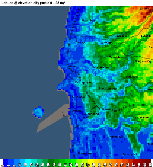
Below is the Elevation map of Labuan, which displays elevation range with different colors. Scale of the first map is from 0 to 98 m (0 to 322 ft) with average elevation of 25.1 meters (=82 ft) [note 1]
These maps also provides idea of topography and contour of this city, they are displayed at different zoom levels. More info about maps, scale and edge coordinates you can find below images.
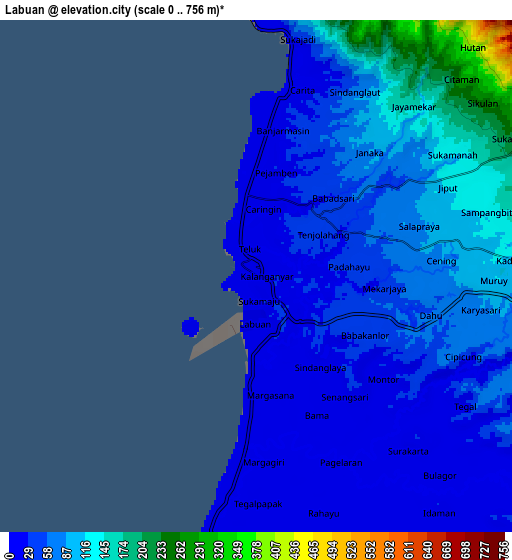
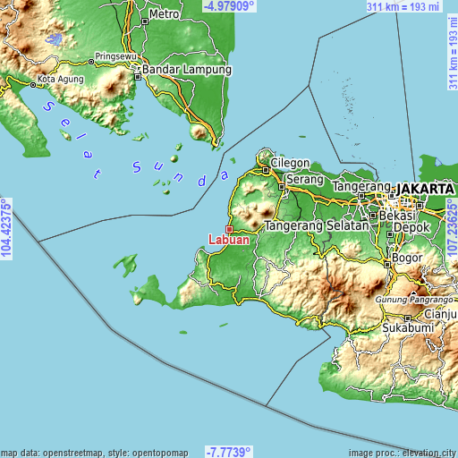
| \ | Map #1 | Map #2 | Topo.Map |
| Scale [m] | 0..98 m | 0..756 m | × |
| Scale [ft] | 0..322 ft | 0..2480 ft | × |
| Average | 25.1 m = 82 ft | 66 m = 217 ft | × |
| Width | 9.71 km = 6 mi | 19.42 km = 12.1 mi | 310.8 km = 193.1 mi |
| Height | 9.71 km = 6 mi | 19.42 km = 12.1 mi | 310.8 km = 193.1 mi |
| ↑Max Latitude | -6.334725° | -6.291046° | -4.97909° |
| Latitude at center | -6.3784° | -6.3784° | -6.3784° |
| ↓Min Latitude | -6.422071° | -6.465739° | -7.7739° |
| ← Min Longitude | 105.786055° | 105.742109° | 104.42375° |
| Longitude center | 105.83° | 105.83° | 105.83° |
| →Max Longitude | 105.873945° | 105.917891° | 107.23625° |
Nearby cities:
Cities around Labuan sort by population:
• Cigeulis elevation 88 m
27.8 km,  213°
213°
• Cilegong 48 m
26.6 km,  135°
135°
• Pasanggrahan 32 m
26.5 km,  161°
161°
• Kopibera 56 m
25.3 km,  10°
10°
• Batubantar 203 m
23.9 km,  82°
82°
• Padarincang 105 m
22.7 km,  36°
36°
• Mandalawangi 429 m
19.1 km,  66°
66°
• Saketi 137 m
18.1 km,  97°
97°
• Panimbang 5 m
13.4 km,  196°
196°
• Menes 115 m
9.8 km,  88°
88°
• Pagelaran 10 m
6.8 km,  153°
153°
• Sukacai 66 m
5.2 km,  50°
50°
Multilingual:
 En español:
Labuan elevación 12 m.
 En France:
Labuan élévation 12 m.


Sources and notes:
- [note 1] Map square and city borders are not equal. Map elevation data is calculated only from area inside that square.
- [src 1] Elevation data from geonames database provided with same terms of usage.
- [src 2] The elevation map of Labuan is generated using elevation data from NASA's 3 arcsec (90m) resolution SRTM data.
- [src 3] Base (background) map © OpenStreetMap contributors tiles are generated by Geofabrik and OpenTopoMap.
Copyright & License:
This Labuan Elevation Map is licensed under CC BY-SA. You may reuse any part from this page, if you give a proper credit by linking to this URL:
 More info on terms of use page.