Cilegong elevation
Cilegong (Banten), Indonesia elevation is 48 meters and Cilegong elevation in feet is 157 ft above sea level [src 1]. Cilegong is a seat of a third-order administrative division (feature code) with elevation that is 143 meters (469 ft) smaller than average city elevation in Indonesia.
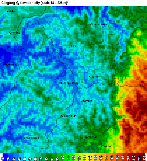
Below is the Elevation map of Cilegong, which displays elevation range with different colors. Scale of the first map is from 18 to 228 m (59 to 748 ft) with average elevation of 75.4 meters (=247 ft) [note 1]
These maps also provides idea of topography and contour of this city, they are displayed at different zoom levels. More info about maps, scale and edge coordinates you can find below images.
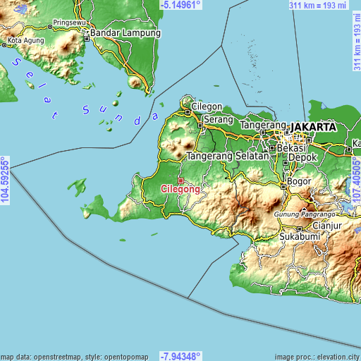
| \ | Map #1 | Topo.Map |
| Scale [m] | 18..228 m | × |
| Scale [ft] | 59..748 ft | × |
| Average | 75.4 m = 247 ft | × |
| Width | 9.71 km = 6 mi | 310.6 km = 193 mi |
| Height | 9.71 km = 6 mi | 310.7 km = 193.1 mi |
| ↑Max Latitude | -6.504839° | -5.14961° |
| Latitude at center | -6.5485° | -6.5485° |
| ↓Min Latitude | -6.592157° | -7.94348° |
| ← Min Longitude | 105.954855° | 104.59255° |
| Longitude center | 105.9988° | 105.9988° |
| →Max Longitude | 106.042745° | 107.40505° |
Nearby cities:
Cities around Cilegong sort by population:
• Kadugedong elevation 118 m
23.4 km,  28°
28°
• Panimbang 5 m
23.2 km,  285°
285°
• Batubantar 203 m
22.6 km,  12°
12°
• Leuwidamar 43 m
21.9 km,  79°
79°
• Menes 115 m
21.2 km,  335°
335°
• Pagelaran 10 m
20.2 km,  309°
309°
• Sukamaju 292 m
19.1 km,  155°
155°
• Bojongmanik Girang 110 m
18.9 km,  102°
102°
• Saketi 137 m
16.4 km,  357°
357°
• Pasanggrahan 32 m
12.2 km,  238°
238°
• Sajir 119 m
10.7 km,  64°
64°
• Gunungkencana 278 m
8.7 km,  107°
107°
Multilingual:
 En español:
Cilegong elevación 48 m.
 En France:
Cilegong élévation 48 m.


Sources and notes:
- [note 1] Map square and city borders are not equal. Map elevation data is calculated only from area inside that square.
- [src 1] Elevation data from geonames database provided with same terms of usage.
- [src 2] The elevation map of Cilegong is generated using elevation data from NASA's 3 arcsec (90m) resolution SRTM data.
- [src 3] Base (background) map © OpenStreetMap contributors tiles are generated by Geofabrik and OpenTopoMap.
Copyright & License:
This Cilegong Elevation Map is licensed under CC BY-SA. You may reuse any part from this page, if you give a proper credit by linking to this URL:
 More info on terms of use page.