Ngawi elevation
Ngawi (West Java), Indonesia elevation is 57 meters and Ngawi elevation in feet is 187 ft above sea level [src 1]. Ngawi is a populated place (feature code) with elevation that is 134 meters (440 ft) smaller than average city elevation in Indonesia.
Below is the Elevation map of Ngawi, which displays elevation range with different colors. Scale of the first map is from 38 to 159 m (125 to 522 ft) with average elevation of 61.4 meters (=201 ft) [note 1]
These maps also provides idea of topography and contour of this city, they are displayed at different zoom levels. More info about maps, scale and edge coordinates you can find below images.
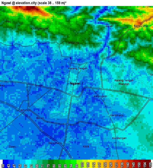
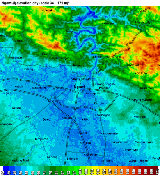
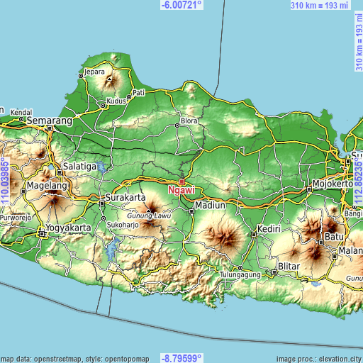
| \ | Map #1 | Map #2 | Topo.Map |
| Scale [m] | 38..159 m | 34..171 m | × |
| Scale [ft] | 125..522 ft | 112..561 ft | × |
| Average | 61.4 m = 201 ft | 70.7 m = 232 ft | × |
| Width | 9.69 km = 6 mi | 19.38 km = 12 mi | 310.1 km = 192.7 mi |
| Height | 9.69 km = 6 mi | 19.38 km = 12 mi | 310.1 km = 192.7 mi |
| ↑Max Latitude | -7.360219° | -7.316634° | -6.00721° |
| Latitude at center | -7.4038° | -7.4038° | -7.4038° |
| ↓Min Latitude | -7.447377° | -7.490949° | -8.79599° |
| ← Min Longitude | 111.402155° | 111.358209° | 110.03985° |
| Longitude center | 111.4461° | 111.4461° | 111.4461° |
| →Max Longitude | 111.490045° | 111.533991° | 112.85235° |
Nearby cities:
Cities around Ngawi sort by population:
• Madiun elevation 69 m
26.6 km,  161°
161°
• Sragen 90 m
46.8 km,  266°
266°
• Cepu 36 m
32.7 km,  29°
29°
• Jepon 108 m
48.1 km,  4°
4°
• Ngawen 81 m
46.9 km,  341°
341°
• Watulumbung 122 m
44.9 km,  9°
9°
• Banjarejo 85 m
42.6 km, 344°
• Pengkok 33 m
32 km, 34°
• Magetan 356 m
30.8 km,  204°
204°
• Caruban 80 m
28 km,  124°
124°
• Ngraho 55 m
26.5 km, 12°
• Menden 49 m
17.5 km, 3°
Multilingual:
 En español:
Ngawi elevación 57 m.
 En France:
Ngawi élévation 57 m.


Sources and notes:
- [note 1] Map square and city borders are not equal. Map elevation data is calculated only from area inside that square.
- [src 1] Elevation data from geonames database provided with same terms of usage.
- [src 2] The elevation map of Ngawi is generated using elevation data from NASA's 3 arcsec (90m) resolution SRTM data.
- [src 3] Base (background) map © OpenStreetMap contributors tiles are generated by Geofabrik and OpenTopoMap.
Copyright & License:
This Ngawi Elevation Map is licensed under CC BY-SA. You may reuse any part from this page, if you give a proper credit by linking to this URL:
 More info on terms of use page.