Palopo elevation
Palopo (South Sulawesi), Indonesia elevation is 8 meters and Palopo elevation in feet is 26 ft above sea level [src 1]. Palopo is a populated place (feature code) with elevation that is 183 meters (600 ft) smaller than average city elevation in Indonesia.
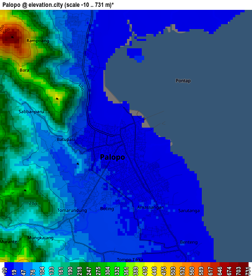
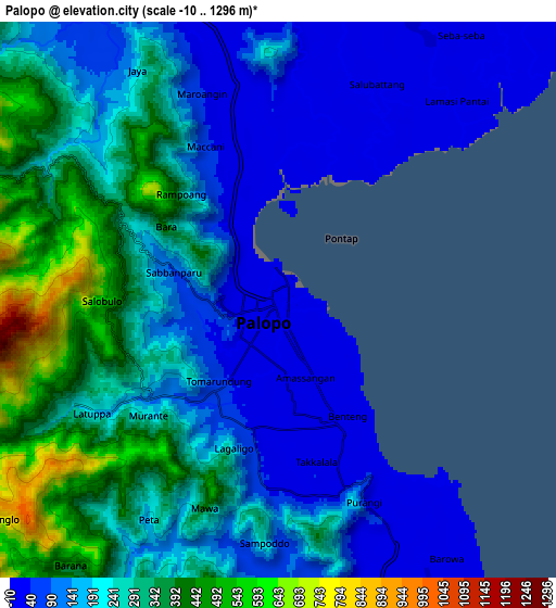
Below is the Elevation map of Palopo, which displays elevation range with different colors. Scale of the first map is from -10 to 731 m (-33 to 2398 ft) with average elevation of 96.2 meters (=316 ft) [note 1]
These maps also provides idea of topography and contour of this city, they are displayed at different zoom levels. More info about maps, scale and edge coordinates you can find below images.
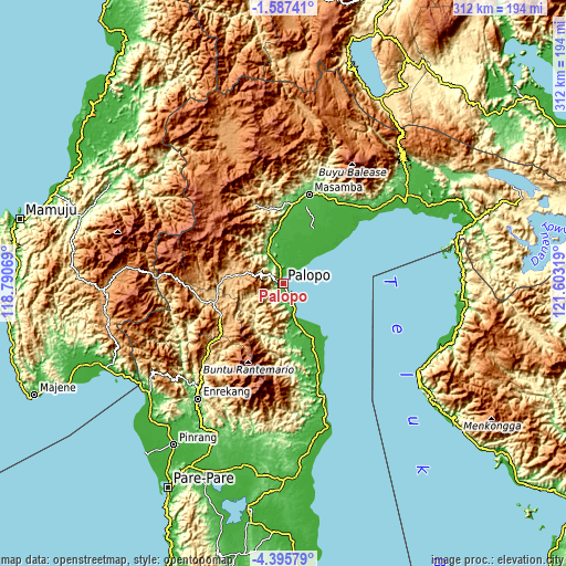
| \ | Map #1 | Map #2 | Topo.Map |
| Scale [m] | -10..731 m | -10..1296 m | × |
| Scale [ft] | -33..2398 ft | -33..4252 ft | × |
| Average | 96.2 m = 316 ft | 223 m = 732 ft | × |
| Width | 9.76 km = 6.1 mi | 19.52 km = 12.1 mi | 312.3 km = 194.1 mi |
| Height | 9.76 km = 6.1 mi | 19.52 km = 12.1 mi | 312.3 km = 194.1 mi |
| ↑Max Latitude | -2.948614° | -2.904726° | -1.58741° |
| Latitude at center | -2.9925° | -2.9925° | -2.9925° |
| ↓Min Latitude | -3.036385° | -3.080267° | -4.39579° |
| ← Min Longitude | 120.152995° | 120.109049° | 118.79069° |
| Longitude center | 120.19694° | 120.19694° | 120.19694° |
| →Max Longitude | 120.240885° | 120.284831° | 121.60319° |
Nearby cities:
Cities around Palopo sort by population:
• Rantepao elevation 784 m
33.3 km,  274°
274°
• Rindingallo 1200 m
43.8 km,  283°
283°
• Getengan 1040 m
40.6 km,  238°
238°
• Makale 762 m
40 km,  252°
252°
• Totumbang 788 m
32.1 km, 252°
• Rantepang 829 m
29.4 km, 284°
• Padangsappa 21 m
29.3 km,  156°
156°
• Beuma 341 m
29.1 km,  213°
213°
• Lamasi 31 m
19.7 km,  353°
353°
• Walenrang 76 m
18.7 km,  333°
333°
• Batuputih 32 m
4.2 km,  335°
335°
• Beringinjaya 9 m
1.9 km,  149°
149°
Multilingual:
 En español:
Palopo elevación 8 m.
 En France:
Palopo élévation 8 m.


Sources and notes:
- [note 1] Map square and city borders are not equal. Map elevation data is calculated only from area inside that square.
- [src 1] Elevation data from geonames database provided with same terms of usage.
- [src 2] The elevation map of Palopo is generated using elevation data from NASA's 3 arcsec (90m) resolution SRTM data.
- [src 3] Base (background) map © OpenStreetMap contributors tiles are generated by Geofabrik and OpenTopoMap.
Copyright & License:
This Palopo Elevation Map is licensed under CC BY-SA. You may reuse any part from this page, if you give a proper credit by linking to this URL:
 More info on terms of use page.