Pototano elevation
Pototano (West Nusa Tenggara), Indonesia elevation is 5 meters and Pototano elevation in feet is 16 ft above sea level [src 1]. Pototano is a populated place (feature code) with elevation that is 186 meters (610 ft) smaller than average city elevation in Indonesia.
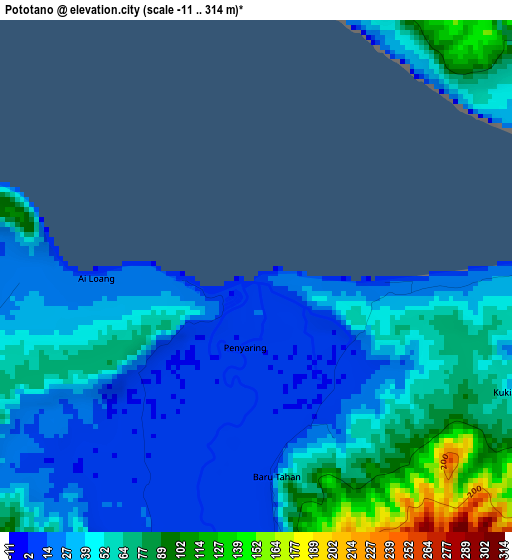
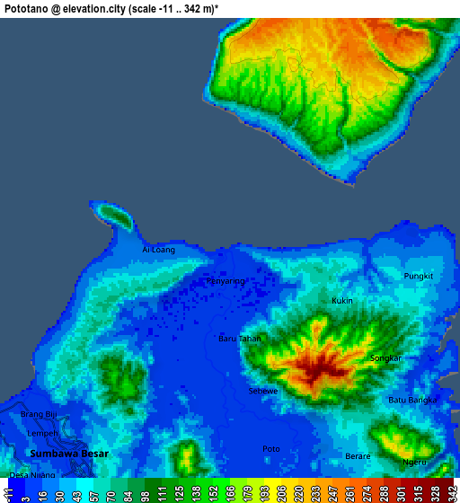
Below is the Elevation map of Pototano, which displays elevation range with different colors. Scale of the first map is from -11 to 314 m (-36 to 1030 ft) with average elevation of 45.7 meters (=150 ft) [note 1]
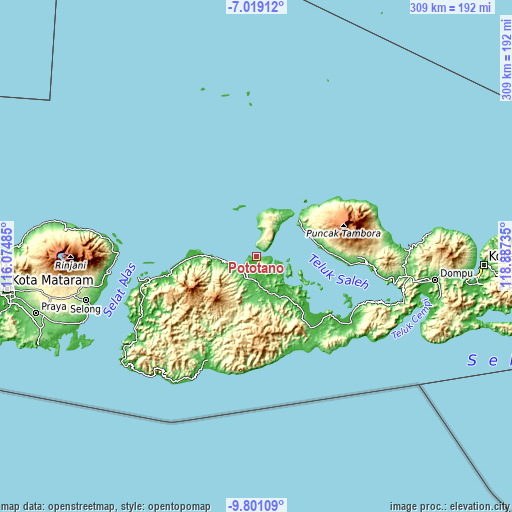
These maps also provides idea of topography and contour of this city, they are displayed at different zoom levels. More info about maps, scale and edge coordinates you can find below images.
| \ | Map #1 | Map #2 | Topo.Map |
| Scale [m] | -11..314 m | -11..342 m | × |
| Scale [ft] | -36..1030 ft | -36..1122 ft | × |
| Average | 45.7 m = 150 ft | 72.4 m = 238 ft | × |
| Width | 9.67 km = 6 mi | 19.33 km = 12 mi | 309.3 km = 192.2 mi |
| Height | 9.67 km = 6 mi | 19.33 km = 12 mi | 309.4 km = 192.3 mi |
| ↑Max Latitude | -8.369125° | -8.325645° | -7.01912° |
| Latitude at center | -8.4126° | -8.4126° | -8.4126° |
| ↓Min Latitude | -8.45607° | -8.499535° | -9.80109° |
| ← Min Longitude | 117.437155° | 117.393209° | 116.07485° |
| Longitude center | 117.4811° | 117.4811° | 117.4811° |
| →Max Longitude | 117.525045° | 117.568991° | 118.88735° |
Nearby cities:
Cities around Pototano sort by population:
• Sumbawa Besar elevation 14 m
11.2 km,  216°
216°
• Kempo 26 m
85.6 km,  99°
99°
• Taliwang 14 m
78.3 km,  241°
241°
• Muraloka 26 m
77.3 km, 238°
• Senayan 45 m
72.8 km,  252°
252°
• Seteluk 32 m
71.6 km, 250°
• Tepas 21 m
70.7 km, 241°
• Plampang 34 m
53.9 km,  142°
142°
• Utan 33 m
38.3 km,  269°
269°
• Lenangguar 246 m
38.1 km,  199°
199°
• Semamung 102 m
27.2 km,  192°
192°
• Semongkat 319 m
25.1 km,  225°
225°
Multilingual:
 En español:
Pototano elevación 5 m.
 En France:
Pototano élévation 5 m.


Sources and notes:
- [note 1] Map square and city borders are not equal. Map elevation data is calculated only from area inside that square.
- [src 1] Elevation data from geonames database provided with same terms of usage.
- [src 2] The elevation map of Pototano is generated using elevation data from NASA's 3 arcsec (90m) resolution SRTM data.
- [src 3] Base (background) map © OpenStreetMap contributors tiles are generated by Geofabrik and OpenTopoMap.
Copyright & License:
This Pototano Elevation Map is licensed under CC BY-SA. You may reuse any part from this page, if you give a proper credit by linking to this URL:
 More info on terms of use page.