Taliwang elevation
Taliwang (West Nusa Tenggara), Indonesia elevation is 14 meters and Taliwang elevation in feet is 46 ft above sea level [src 1]. Taliwang is a seat of a second-order administrative division (feature code) with elevation that is 177 meters (581 ft) smaller than average city elevation in Indonesia.
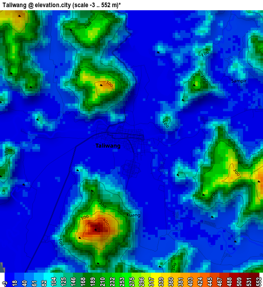
Below is the Elevation map of Taliwang, which displays elevation range with different colors. Scale of the first map is from -3 to 552 m (-10 to 1811 ft) with average elevation of 75.5 meters (=248 ft) [note 1]
These maps also provides idea of topography and contour of this city, they are displayed at different zoom levels. More info about maps, scale and edge coordinates you can find below images.
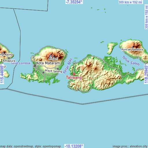
| \ | Map #1 | Topo.Map |
| Scale [m] | -3..552 m | × |
| Scale [ft] | -10..1811 ft | × |
| Average | 75.5 m = 248 ft | × |
| Width | 9.66 km = 6 mi | 309.1 km = 192.1 mi |
| Height | 9.66 km = 6 mi | 309.1 km = 192.1 mi |
| ↑Max Latitude | -8.701463° | -7.35254° |
| Latitude at center | -8.7449° | -8.7449° |
| ↓Min Latitude | -8.788332° | -10.13208° |
| ← Min Longitude | 116.809255° | 115.44695° |
| Longitude center | 116.8532° | 116.8532° |
| →Max Longitude | 116.897145° | 118.25945° |
Nearby cities:
Cities around Taliwang sort by population:
• Labuan Lombok elevation 5 m
34.1 km,  323°
323°
• Masbagik 276 m
43.5 km,  288°
288°
• Sakra 227 m
43.5 km,  279°
279°
• Aikmel 272 m
40.6 km,  299°
299°
• Sukamulia 206 m
39.6 km, 289°
• Selong 156 m
36.9 km, 286°
• Pringgabaya 27 m
32.1 km,  310°
310°
• Sekongkang Bawah 11 m
27.1 km,  204°
204°
• Senayan 45 m
14.7 km,  358°
358°
• Seteluk 32 m
13.4 km,  6°
6°
• Tepas 21 m
7.6 km,  65°
65°
• Muraloka 26 m
4.2 km,  136°
136°
Multilingual:
 En español:
Taliwang elevación 14 m.
 En France:
Taliwang élévation 14 m.


Sources and notes:
- [note 1] Map square and city borders are not equal. Map elevation data is calculated only from area inside that square.
- [src 1] Elevation data from geonames database provided with same terms of usage.
- [src 2] The elevation map of Taliwang is generated using elevation data from NASA's 3 arcsec (90m) resolution SRTM data.
- [src 3] Base (background) map © OpenStreetMap contributors tiles are generated by Geofabrik and OpenTopoMap.
Copyright & License:
This Taliwang Elevation Map is licensed under CC BY-SA. You may reuse any part from this page, if you give a proper credit by linking to this URL:
 More info on terms of use page.