Sape elevation
Sape, Indonesia elevation is 27 meters and Sape elevation in feet is 89 ft above sea level [src 1]. Sape is a populated place (feature code) with elevation that is 164 meters (538 ft) smaller than average city elevation in Indonesia.
Below is the Elevation map of Sape, which displays elevation range with different colors. Scale of the first map is from 0 to 477 m (0 to 1565 ft) with average elevation of 109 meters (=358 ft) [note 1]
These maps also provides idea of topography and contour of this city, they are displayed at different zoom levels. More info about maps, scale and edge coordinates you can find below images.
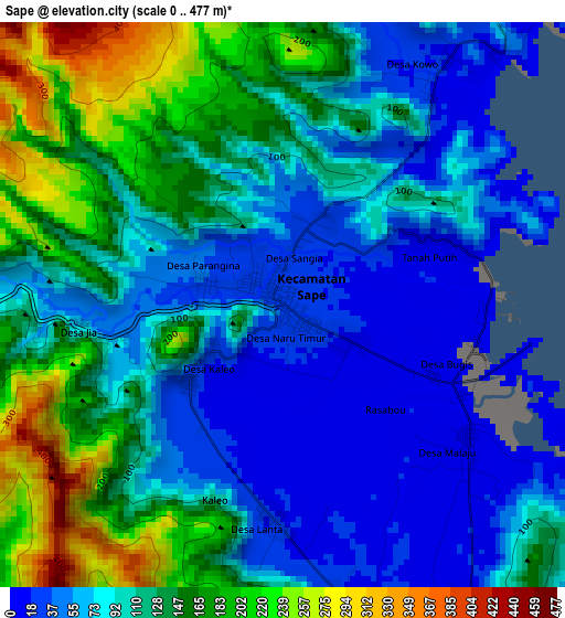
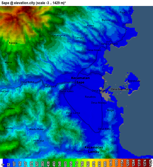
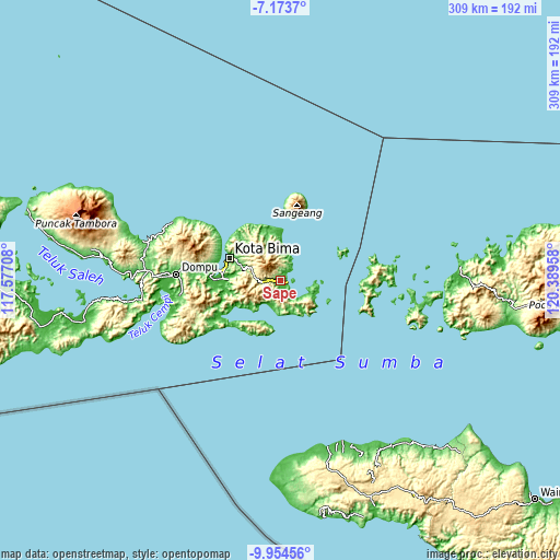
| \ | Map #1 | Map #2 | Topo.Map |
| Scale [m] | 0..477 m | -3..1429 m | × |
| Scale [ft] | 0..1565 ft | -10..4688 ft | × |
| Average | 109 m = 358 ft | 271.5 m = 891 ft | × |
| Width | 9.66 km = 6 mi | 19.33 km = 12 mi | 309.2 km = 192.1 mi |
| Height | 9.66 km = 6 mi | 19.33 km = 12 mi | 309.2 km = 192.1 mi |
| ↑Max Latitude | -8.523212° | -8.47975° | -7.1737° |
| Latitude at center | -8.56667° | -8.56667° | -8.56667° |
| ↓Min Latitude | -8.610123° | -8.65357° | -9.95456° |
| ← Min Longitude | 118.939385° | 118.895439° | 117.57708° |
| Longitude center | 118.98333° | 118.98333° | 118.98333° |
| →Max Longitude | 119.027275° | 119.071221° | 120.38958° |
Nearby cities:
Cities around Sape sort by population:
• Bima elevation 15 m
30.6 km,  292°
292°
• Dompu 32 m
57.3 km,  273°
273°
• Komodo 8 m
55.9 km,  92°
92°
• Donggo 690 m
45.5 km, 290°
• Sila 24 m
40.6 km,  280°
280°
• Woha 51 m
37.3 km,  261°
261°
• Godo 4 m
34.8 km, 271°
• Tangga 41 m
33.4 km,  252°
252°
• Raba 19 m
28.5 km, 294°
• Tawali 57 m
26.2 km,  343°
343°
• Maria 387 m
16.2 km, 287°
• Naru 18 m
1.2 km,  119°
119°
Multilingual:
 En español:
Sape elevación 27 m.
 En France:
Sape élévation 27 m.


Sources and notes:
- [note 1] Map square and city borders are not equal. Map elevation data is calculated only from area inside that square.
- [src 1] Elevation data from geonames database provided with same terms of usage.
- [src 2] The elevation map of Sape is generated using elevation data from NASA's 3 arcsec (90m) resolution SRTM data.
- [src 3] Base (background) map © OpenStreetMap contributors tiles are generated by Geofabrik and OpenTopoMap.
Copyright & License:
This Sape Elevation Map is licensed under CC BY-SA. You may reuse any part from this page, if you give a proper credit by linking to this URL:
 More info on terms of use page.