Sleman elevation
Sleman (Yogyakarta), Indonesia elevation is 210 meters and Sleman elevation in feet is 689 ft above sea level [src 1]. Sleman is a seat of a second-order administrative division (feature code) with elevation that is 19 meters (62 ft) bigger than average city elevation in Indonesia.
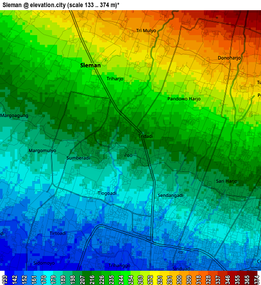
Below is the Elevation map of Sleman, which displays elevation range with different colors. Scale of the first map is from 133 to 374 m (436 to 1227 ft) with average elevation of 218.1 meters (=716 ft) [note 1]
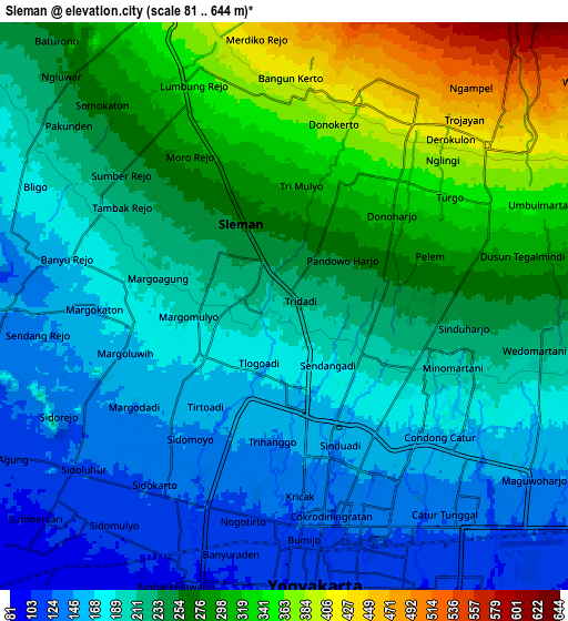
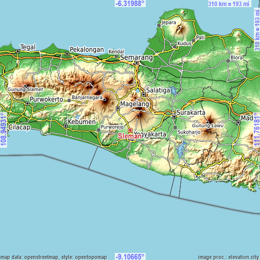
These maps also provides idea of topography and contour of this city, they are displayed at different zoom levels. More info about maps, scale and edge coordinates you can find below images.
| \ | Map #1 | Map #2 | Topo.Map |
| Scale [m] | 133..374 m | 81..644 m | × |
| Scale [ft] | 436..1227 ft | 266..2113 ft | × |
| Average | 218.1 m = 716 ft | 231.4 m = 759 ft | × |
| Width | 9.68 km = 6 mi | 19.37 km = 12 mi | 309.9 km = 192.6 mi |
| Height | 9.68 km = 6 mi | 19.37 km = 12 mi | 309.9 km = 192.6 mi |
| ↑Max Latitude | -7.67201° | -7.628456° | -6.31988° |
| Latitude at center | -7.71556° | -7.71556° | -7.71556° |
| ↓Min Latitude | -7.759105° | -7.802646° | -9.10665° |
| ← Min Longitude | 110.311615° | 110.267669° | 108.94931° |
| Longitude center | 110.35556° | 110.35556° | 110.35556° |
| →Max Longitude | 110.399505° | 110.443451° | 111.76181° |
Nearby cities:
Cities around Sleman sort by population:
• Yogyakarta elevation 110 m
9.6 km,  173°
173°
• Depok 154 m
9.9 km,  121°
121°
• Kasihan 86 m
12.7 km,  193°
193°
• Sewon 57 m
17.9 km,  178°
178°
• Melati 187 m
2.3 km,  148°
148°
• Gamping Lor 105 m
9.5 km,  199°
199°
• Godean 121 m
9.1 km,  228°
228°
• Bantul 49 m
19.4 km, 188°
• Candi Prambanan 157 m
15.7 km,  104°
104°
• Muntilan 377 m
16.5 km,  335°
335°
• Jogonalan 223 m
19.9 km,  86°
86°
• Mungkid 250 m
20.3 km,  312°
312°
Multilingual:
 En español:
Sleman elevación 210 m.
 En France:
Sleman élévation 210 m.


Sources and notes:
- [note 1] Map square and city borders are not equal. Map elevation data is calculated only from area inside that square.
- [src 1] Elevation data from geonames database provided with same terms of usage.
- [src 2] The elevation map of Sleman is generated using elevation data from NASA's 3 arcsec (90m) resolution SRTM data.
- [src 3] Base (background) map © OpenStreetMap contributors tiles are generated by Geofabrik and OpenTopoMap.
Copyright & License:
This Sleman Elevation Map is licensed under CC BY-SA. You may reuse any part from this page, if you give a proper credit by linking to this URL:
 More info on terms of use page.