Kasihan elevation
Kasihan (Yogyakarta), Indonesia elevation is 86 meters and Kasihan elevation in feet is 282 ft above sea level [src 1]. Kasihan is a populated place (feature code) with elevation that is 105 meters (344 ft) smaller than average city elevation in Indonesia.
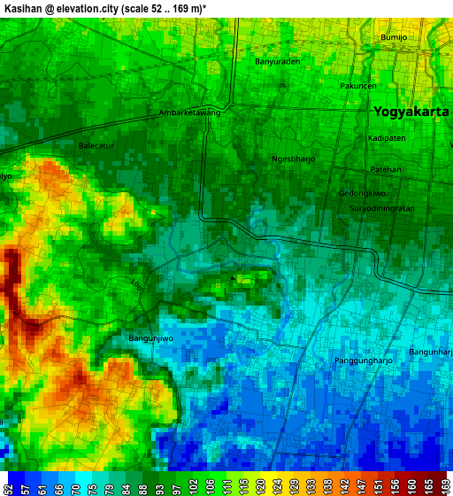
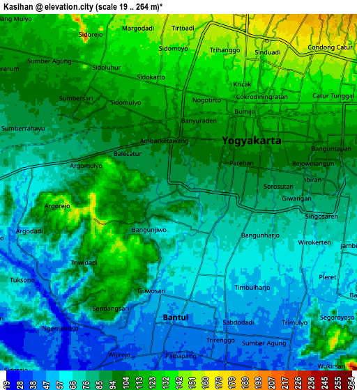
Below is the Elevation map of Kasihan, which displays elevation range with different colors. Scale of the first map is from 52 to 169 m (171 to 554 ft) with average elevation of 93.8 meters (=308 ft) [note 1]
These maps also provides idea of topography and contour of this city, they are displayed at different zoom levels. More info about maps, scale and edge coordinates you can find below images.
| \ | Map #1 | Map #2 | Topo.Map |
| Scale [m] | 52..169 m | 19..264 m | × |
| Scale [ft] | 171..554 ft | 62..866 ft | × |
| Average | 93.8 m = 308 ft | 91.1 m = 299 ft | × |
| Width | 9.68 km = 6 mi | 19.36 km = 12 mi | 309.8 km = 192.5 mi |
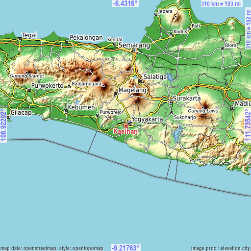
| Height | 9.68 km = 6 mi | 19.36 km = 12 mi | 309.8 km = 192.5 mi |
| ↑Max Latitude | -7.783402° | -7.739859° | -6.4316° |
| Latitude at center | -7.82694° | -7.82694° | -7.82694° |
| ↓Min Latitude | -7.870474° | -7.914003° | -9.21763° |
| ← Min Longitude | 110.285225° | 110.241279° | 108.92292° |
| Longitude center | 110.32917° | 110.32917° | 110.32917° |
| →Max Longitude | 110.373115° | 110.417061° | 111.73542° |
Nearby cities:
Cities around Kasihan sort by population:
• Yogyakarta elevation 110 m
4.8 km,  54°
54°
• Depok 154 m
13.4 km,  57°
57°
• Sewon 57 m
6.4 km,  149°
149°
• Melati 187 m
11.2 km,  21°
21°
• Gamping Lor 105 m
3.5 km,  354°
354°
• Godean 121 m
7.5 km,  328°
328°
• Bantul 49 m
6.8 km,  180°
180°
• Sleman 210 m
12.7 km,  13°
13°
• Pandak 34 m
10.3 km,  202°
202°
• Bambanglipuro 37 m
14.6 km, 200°
• Srandakan 23 m
15.1 km,  214°
214°
• Pundong 26 m
14.1 km,  171°
171°
Multilingual:
 En español:
Kasihan elevación 86 m.
 En France:
Kasihan élévation 86 m.


Sources and notes:
- [note 1] Map square and city borders are not equal. Map elevation data is calculated only from area inside that square.
- [src 1] Elevation data from geonames database provided with same terms of usage.
- [src 2] The elevation map of Kasihan is generated using elevation data from NASA's 3 arcsec (90m) resolution SRTM data.
- [src 3] Base (background) map © OpenStreetMap contributors tiles are generated by Geofabrik and OpenTopoMap.
Copyright & License:
This Kasihan Elevation Map is licensed under CC BY-SA. You may reuse any part from this page, if you give a proper credit by linking to this URL:
 More info on terms of use page.