Teluk Kuantan elevation
Teluk Kuantan (Riau), Indonesia elevation is 54 meters and Teluk Kuantan elevation in feet is 177 ft above sea level [src 1]. Teluk Kuantan is a seat of a second-order administrative division (feature code) with elevation that is 137 meters (449 ft) smaller than average city elevation in Indonesia.
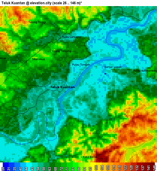
Below is the Elevation map of Teluk Kuantan, which displays elevation range with different colors. Scale of the first map is from 26 to 146 m (85 to 479 ft) with average elevation of 69.9 meters (=229 ft) [note 1]
These maps also provides idea of topography and contour of this city, they are displayed at different zoom levels. More info about maps, scale and edge coordinates you can find below images.
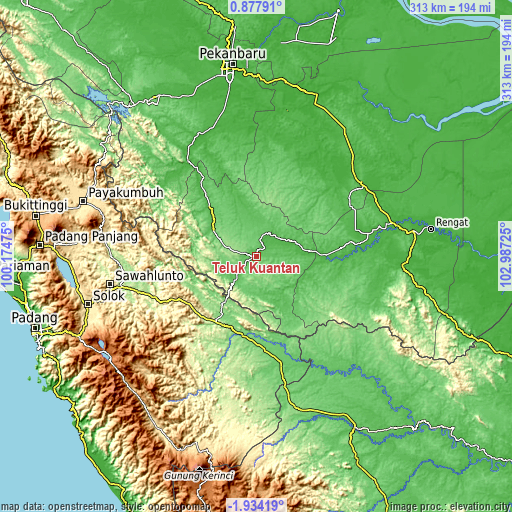
| \ | Map #1 | Topo.Map |
| Scale [m] | 26..146 m | × |
| Scale [ft] | 85..479 ft | × |
| Average | 69.9 m = 229 ft | × |
| Width | 9.77 km = 6.1 mi | 312.7 km = 194.3 mi |
| Height | 9.77 km = 6.1 mi | 312.7 km = 194.3 mi |
| ↑Max Latitude | -0.484356° | 0.87791° |
| Latitude at center | -0.5283° | -0.5283° |
| ↓Min Latitude | -0.572243° | -1.93419° |
| ← Min Longitude | 101.537055° | 100.17475° |
| Longitude center | 101.581° | 101.581° |
| →Max Longitude | 101.624945° | 102.98725° |
Nearby cities:
Cities around Teluk Kuantan sort by population:
• Sijunjung elevation 167 m
69.8 km,  254°
254°
• Kototujuh 202 m
77.9 km,  261°
261°
• Sumpur Kudus 336 m
75.4 km,  277°
277°
• Muaro 171 m
70.9 km, 257°
• Kotabaru 84 m
66.8 km,  162°
162°
• Tanjunggadang 330 m
50.8 km,  236°
236°
• Pulau Punjung 114 m
48.7 km,  190°
190°
• Peranap 29 m
44.8 km,  92°
92°
• Cerenti 41 m
32.1 km, 86°
• Muaralembu 63 m
31.5 km,  301°
301°
• Baserah 34 m
20.3 km,  63°
63°
• Lubukjambi 64 m
18.6 km,  222°
222°
Multilingual:
 En español:
Teluk Kuantan elevación 54 m.
 En France:
Teluk Kuantan élévation 54 m.
 Auf Deutsch:
Teluk Kuantan höhe über dem Meeresspiegel ist 54 m.

Sources and notes:
- [note 1] Map square and city borders are not equal. Map elevation data is calculated only from area inside that square.
- [src 1] Elevation data from geonames database provided with same terms of usage.
- [src 2] The elevation map of Teluk Kuantan is generated using elevation data from NASA's 3 arcsec (90m) resolution SRTM data.
- [src 3] Base (background) map © OpenStreetMap contributors tiles are generated by Geofabrik and OpenTopoMap.
Copyright & License:
This Teluk Kuantan Elevation Map is licensed under CC BY-SA. You may reuse any part from this page, if you give a proper credit by linking to this URL:
 More info on terms of use page.