Pematangsiantar elevation
Pematangsiantar (North Sumatra), Indonesia elevation is 388 meters and Pematangsiantar elevation in feet is 1273 ft above sea level [src 1]. Pematangsiantar is a populated place (feature code) with elevation that is 197 meters (646 ft) bigger than average city elevation in Indonesia.
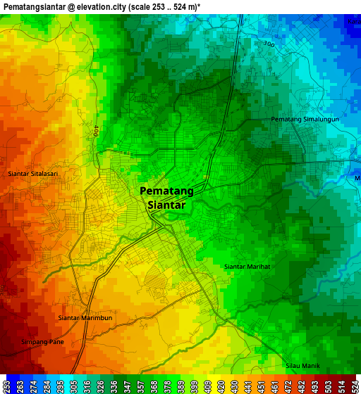
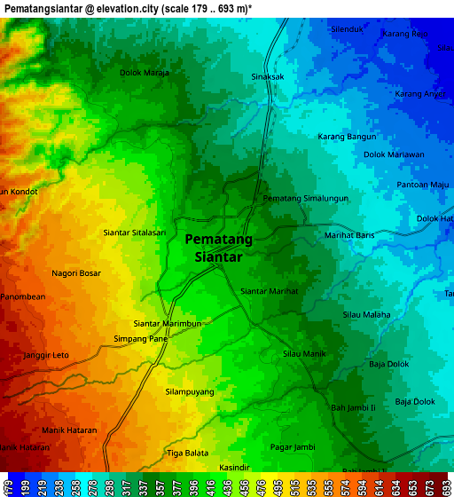
Below is the Elevation map of Pematangsiantar, which displays elevation range with different colors. Scale of the first map is from 253 to 524 m (830 to 1719 ft) with average elevation of 383.4 meters (=1258 ft) [note 1]
These maps also provides idea of topography and contour of this city, they are displayed at different zoom levels. More info about maps, scale and edge coordinates you can find below images.
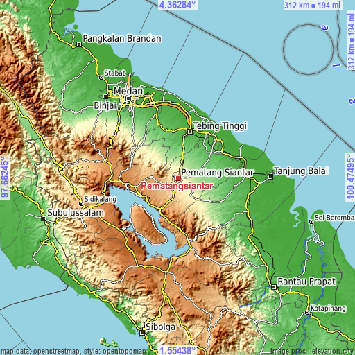
| \ | Map #1 | Map #2 | Topo.Map |
| Scale [m] | 253..524 m | 179..693 m | × |
| Scale [ft] | 830..1719 ft | 587..2274 ft | × |
| Average | 383.4 m = 1258 ft | 386.4 m = 1268 ft | × |
| Width | 9.76 km = 6.1 mi | 19.52 km = 12.1 mi | 312.3 km = 194.1 mi |
| Height | 9.76 km = 6.1 mi | 19.52 km = 12.1 mi | 312.3 km = 194.1 mi |
| ↑Max Latitude | 3.003386° | 3.04727° | 4.36284° |
| Latitude at center | 2.9595° | 2.9595° | 2.9595° |
| ↓Min Latitude | 2.915612° | 2.871723° | 1.55438° |
| ← Min Longitude | 99.024755° | 98.980809° | 97.66245° |
| Longitude center | 99.0687° | 99.0687° | 99.0687° |
| →Max Longitude | 99.112645° | 99.156591° | 100.47495° |
Nearby cities:
Cities around Pematangsiantar sort by population:
• Tebingtinggi elevation 24 m
42.3 km,  14°
14°
• Pekan Bahapal 128 m
20.7 km,  34°
34°
• Tomok Bolon 922 m
41.2 km,  214°
214°
• Parapat 940 m
36.2 km,  204°
204°
• Tuktuk Sonak 914 m
39.9 km,  215°
215°
• Ambarita 909 m
40.6 km, 220°
• Tigarunggu 1313 m
39.1 km,  259°
259°
• Sipintuangin 1218 m
34.9 km,  242°
242°
• Pematang Raya 1013 m
24.6 km,  271°
271°
• Sondi 1010 m
23 km, 273°
• Sarimatondang 847 m
20 km, 238°
• Pane Tongah 672 m
12.3 km, 240°
Multilingual:
 En español:
Pematangsiantar elevación 388 m.
 En France:
Pematangsiantar élévation 388 m.
 Auf Deutsch:
Pematangsiantar höhe über dem Meeresspiegel ist 388 m.

Sources and notes:
- [note 1] Map square and city borders are not equal. Map elevation data is calculated only from area inside that square.
- [src 1] Elevation data from geonames database provided with same terms of usage.
- [src 2] The elevation map of Pematangsiantar is generated using elevation data from NASA's 3 arcsec (90m) resolution SRTM data.
- [src 3] Base (background) map © OpenStreetMap contributors tiles are generated by Geofabrik and OpenTopoMap.
Copyright & License:
This Pematangsiantar Elevation Map is licensed under CC BY-SA. You may reuse any part from this page, if you give a proper credit by linking to this URL:
 More info on terms of use page.