Pekan Bahapal elevation
Pekan Bahapal (North Sumatra), Indonesia elevation is 128 meters and Pekan Bahapal elevation in feet is 420 ft above sea level [src 1]. Pekan Bahapal is a populated place (feature code) with elevation that is 63 meters (207 ft) smaller than average city elevation in Indonesia.
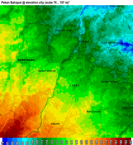
Below is the Elevation map of Pekan Bahapal, which displays elevation range with different colors. Scale of the first map is from 76 to 197 m (249 to 646 ft) with average elevation of 130.7 meters (=429 ft) [note 1]
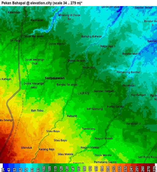
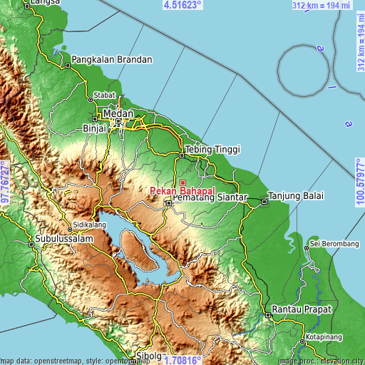
These maps also provides idea of topography and contour of this city, they are displayed at different zoom levels. More info about maps, scale and edge coordinates you can find below images.
| \ | Map #1 | Map #2 | Topo.Map |
| Scale [m] | 76..197 m | 34..279 m | × |
| Scale [ft] | 249..646 ft | 112..915 ft | × |
| Average | 130.7 m = 429 ft | 131.4 m = 431 ft | × |
| Width | 9.76 km = 6.1 mi | 19.52 km = 12.1 mi | 312.2 km = 194 mi |
| Height | 9.76 km = 6.1 mi | 19.52 km = 12.1 mi | 312.3 km = 194.1 mi |
| ↑Max Latitude | 3.15701° | 3.200887° | 4.51623° |
| Latitude at center | 3.11313° | 3.11313° | 3.11313° |
| ↓Min Latitude | 3.069249° | 3.025365° | 1.70816° |
| ← Min Longitude | 99.129575° | 99.085629° | 97.76727° |
| Longitude center | 99.17352° | 99.17352° | 99.17352° |
| →Max Longitude | 99.217465° | 99.261411° | 100.57977° |
Nearby cities:
Cities around Pekan Bahapal sort by population:
• Pematangsiantar elevation 388 m
20.7 km,  214°
214°
• Perbaungan 19 m
56 km,  334°
334°
• Kisaran 20 m
51.1 km,  106°
106°
• Tebingtinggi 24 m
24 km,  357°
357°
• Tigarunggu 1313 m
55.6 km,  244°
244°
• Sipintuangin 1218 m
54 km,  231°
231°
• Sei Rampah 7 m
41.5 km,  354°
354°
• Pematang Raya 1013 m
39.8 km,  245°
245°
• Sarimatondang 847 m
39.8 km, 225°
• Sondi 1010 m
37.9 km, 245°
• Pane Tongah 672 m
32.1 km,  224°
224°
• Limapuluh 29 m
27.8 km,  77°
77°
Multilingual:
 En español:
Pekan Bahapal elevación 128 m.
 En France:
Pekan Bahapal élévation 128 m.
 Auf Deutsch:
Pekan Bahapal höhe über dem Meeresspiegel ist 128 m.

Sources and notes:
- [note 1] Map square and city borders are not equal. Map elevation data is calculated only from area inside that square.
- [src 1] Elevation data from geonames database provided with same terms of usage.
- [src 2] The elevation map of Pekan Bahapal is generated using elevation data from NASA's 3 arcsec (90m) resolution SRTM data.
- [src 3] Base (background) map © OpenStreetMap contributors tiles are generated by Geofabrik and OpenTopoMap.
Copyright & License:
This Pekan Bahapal Elevation Map is licensed under CC BY-SA. You may reuse any part from this page, if you give a proper credit by linking to this URL:
 More info on terms of use page.