Sibolga elevation
Sibolga (North Sumatra), Indonesia elevation is 6 meters and Sibolga elevation in feet is 20 ft above sea level [src 1]. Sibolga is a populated place (feature code) with elevation that is 185 meters (607 ft) smaller than average city elevation in Indonesia.
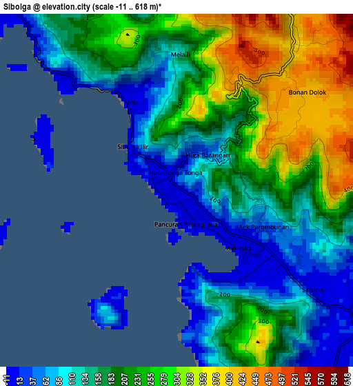
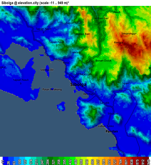
Below is the Elevation map of Sibolga, which displays elevation range with different colors. Scale of the first map is from -11 to 618 m (-36 to 2028 ft) with average elevation of 194.9 meters (=639 ft) [note 1]
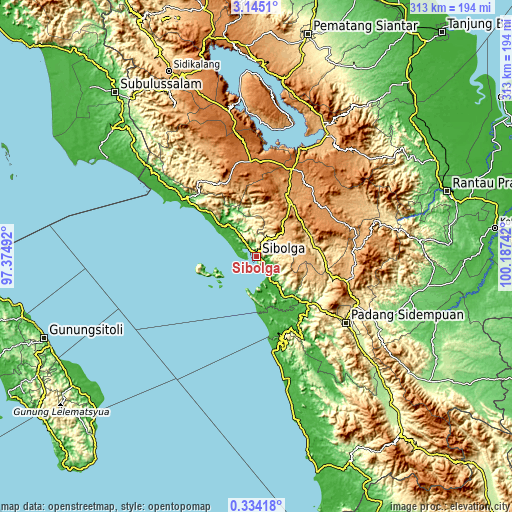
These maps also provides idea of topography and contour of this city, they are displayed at different zoom levels. More info about maps, scale and edge coordinates you can find below images.
| \ | Map #1 | Map #2 | Topo.Map |
| Scale [m] | -11..618 m | -11..949 m | × |
| Scale [ft] | -36..2028 ft | -36..3114 ft | × |
| Average | 194.9 m = 639 ft | 227.3 m = 746 ft | × |
| Width | 9.77 km = 6.1 mi | 19.54 km = 12.1 mi | 312.5 km = 194.2 mi |
| Height | 9.77 km = 6.1 mi | 19.54 km = 12.1 mi | 312.6 km = 194.2 mi |
| ↑Max Latitude | 1.784085° | 1.828008° | 3.1451° |
| Latitude at center | 1.74016° | 1.74016° | 1.74016° |
| ↓Min Latitude | 1.696234° | 1.652308° | 0.33418° |
| ← Min Longitude | 98.737225° | 98.693279° | 97.37492° |
| Longitude center | 98.78117° | 98.78117° | 98.78117° |
| →Max Longitude | 98.825115° | 98.869061° | 100.18742° |
Nearby cities:
Cities around Sibolga sort by population:
• Pakkat elevation 529 m
57.1 km,  323°
323°
• Sipirok 926 m
56.8 km,  105°
105°
• Siborong-Borong 1270 m
56.7 km,  22°
22°
• Barus 5 m
52.1 km,  305°
305°
• Onan Ganjang Satu 1156 m
49.5 km,  340°
340°
• Batangtoru 84 m
42.7 km,  132°
132°
• Parmonangan 1194 m
40.6 km,  357°
357°
• Sipoholon 966 m
40.5 km,  26°
26°
• Sarulla 468 m
37.3 km,  82°
82°
• Tarutung 948 m
36.8 km, 33°
• Sampuran 944 m
36.3 km, 34°
• Pandan 6 m
7.7 km,  144°
144°
Multilingual:
 En español:
Sibolga elevación 6 m.
 En France:
Sibolga élévation 6 m.


Sources and notes:
- [note 1] Map square and city borders are not equal. Map elevation data is calculated only from area inside that square.
- [src 1] Elevation data from geonames database provided with same terms of usage.
- [src 2] The elevation map of Sibolga is generated using elevation data from NASA's 3 arcsec (90m) resolution SRTM data.
- [src 3] Base (background) map © OpenStreetMap contributors tiles are generated by Geofabrik and OpenTopoMap.
Copyright & License:
This Sibolga Elevation Map is licensed under CC BY-SA. You may reuse any part from this page, if you give a proper credit by linking to this URL:
 More info on terms of use page.