Sipoholon elevation
Sipoholon (North Sumatra), Indonesia elevation is 966 meters and Sipoholon elevation in feet is 3169 ft above sea level [src 1]. Sipoholon is a seat of a third-order administrative division (feature code) with elevation that is 775 meters (2543 ft) bigger than average city elevation in Indonesia.
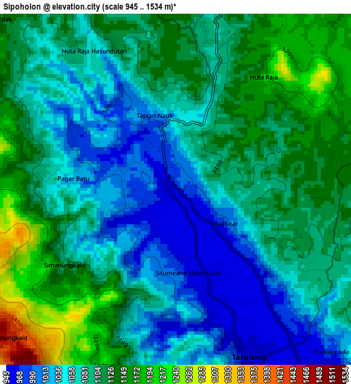
Below is the Elevation map of Sipoholon, which displays elevation range with different colors. Scale of the first map is from 945 to 1534 m (3100 to 5033 ft) with average elevation of 1088.5 meters (=3571 ft) [note 1]
These maps also provides idea of topography and contour of this city, they are displayed at different zoom levels. More info about maps, scale and edge coordinates you can find below images.
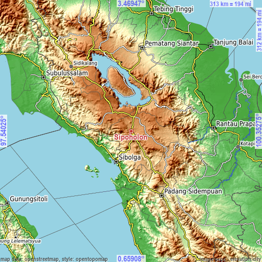
| \ | Map #1 | Topo.Map |
| Scale [m] | 945..1534 m | × |
| Scale [ft] | 3100..5033 ft | × |
| Average | 1088.5 m = 3571 ft | × |
| Width | 9.77 km = 6.1 mi | 312.5 km = 194.2 mi |
| Height | 9.77 km = 6.1 mi | 312.5 km = 194.2 mi |
| ↑Max Latitude | 2.108816° | 3.46947° |
| Latitude at center | 2.0649° | 2.0649° |
| ↓Min Latitude | 2.020983° | 0.65908° |
| ← Min Longitude | 98.902555° | 97.54025° |
| Longitude center | 98.9465° | 98.9465° |
| →Max Longitude | 98.990445° | 100.35275° |
Nearby cities:
Cities around Sipoholon sort by population:
• Sibolga elevation 6 m
40.5 km,  206°
206°
• Nainggolan 916 m
41.8 km,  350°
350°
• Onan Ganjang Satu 1156 m
36.6 km,  286°
286°
• Sarulla 468 m
36.2 km,  149°
149°
• Balige 918 m
32.6 km,  23°
23°
• Dolok Sanggul 1405 m
30.7 km,  314°
314°
• Muara 910 m
30.6 km, 351°
• Lintongnihuta 1407 m
25.1 km,  339°
339°
• Parmonangan 1194 m
20.8 km,  282°
282°
• Siborong-Borong 1270 m
16.7 km,  10°
10°
• Sampuran 944 m
6.7 km,  160°
160°
• Tarutung 948 m
6 km, 159°
Multilingual:
 En español:
Sipoholon elevación 966 m.
 En France:
Sipoholon élévation 966 m.
 Auf Deutsch:
Sipoholon höhe über dem Meeresspiegel ist 966 m.

Sources and notes:
- [note 1] Map square and city borders are not equal. Map elevation data is calculated only from area inside that square.
- [src 1] Elevation data from geonames database provided with same terms of usage.
- [src 2] The elevation map of Sipoholon is generated using elevation data from NASA's 3 arcsec (90m) resolution SRTM data.
- [src 3] Base (background) map © OpenStreetMap contributors tiles are generated by Geofabrik and OpenTopoMap.
Copyright & License:
This Sipoholon Elevation Map is licensed under CC BY-SA. You may reuse any part from this page, if you give a proper credit by linking to this URL:
 More info on terms of use page.