Oksibil elevation
Oksibil (Papua), Indonesia elevation is 1315 meters and Oksibil elevation in feet is 4314 ft above sea level [src 1]. Oksibil is a seat of a second-order administrative division (feature code) with elevation that is 1124 meters (3688 ft) bigger than average city elevation in Indonesia.
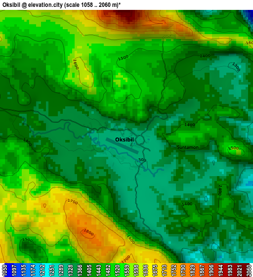
Below is the Elevation map of Oksibil, which displays elevation range with different colors. Scale of the first map is from 1058 to 2060 m (3471 to 6759 ft) with average elevation of 1458 meters (=4783 ft) [note 1]
These maps also provides idea of topography and contour of this city, they are displayed at different zoom levels. More info about maps, scale and edge coordinates you can find below images.
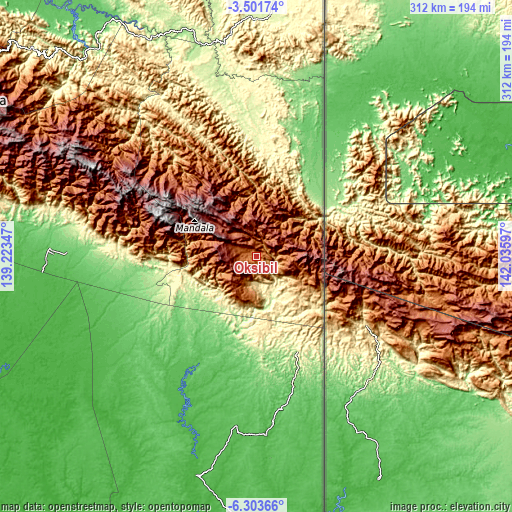
| \ | Map #1 | Topo.Map |
| Scale [m] | 1058..2060 m | × |
| Scale [ft] | 3471..6759 ft | × |
| Average | 1458 m = 4783 ft | × |
| Width | 9.74 km = 6.1 mi | 311.5 km = 193.6 mi |
| Height | 9.74 km = 6.1 mi | 311.6 km = 193.6 mi |
| ↑Max Latitude | -4.860384° | -3.50174° |
| Latitude at center | -4.90417° | -4.90417° |
| ↓Min Latitude | -4.947953° | -6.30366° |
| ← Min Longitude | 140.585775° | 139.22347° |
| Longitude center | 140.62972° | 140.62972° |
| →Max Longitude | 140.673665° | 142.03597° |
Nearby cities:
Cities around Oksibil sort by population:
• Kobakma elevation 961 m
221.6 km,  308°
308°
• Eci 12 m
212.3 km,  230°
230°
• Wamena 1658 m
207.3 km,  295°
295°
• Waris 369 m
200.7 km,  8°
8°
• Banda 509 m
194.9 km, 10°
• Getentiri 16 m
189.9 km,  189°
189°
• Elelim 142 m
163.3 km,  321°
321°
• Sengge 264 m
162.8 km, 5°
• Sumohai 117 m
143.3 km,  279°
279°
• Tanah Merah 26 m
137.4 km,  195°
195°
• Ubrub 411 m
135.3 km, 11°
• Mindiptana 46 m
106.9 km,  176°
176°
Multilingual:
 En español:
Oksibil elevación 1315 m.
 En France:
Oksibil élévation 1315 m.
 Auf Deutsch:
Oksibil höhe über dem Meeresspiegel ist 1315 m.

Sources and notes:
- [note 1] Map square and city borders are not equal. Map elevation data is calculated only from area inside that square.
- [src 1] Elevation data from geonames database provided with same terms of usage.
- [src 2] The elevation map of Oksibil is generated using elevation data from NASA's 3 arcsec (90m) resolution SRTM data.
- [src 3] Base (background) map © OpenStreetMap contributors tiles are generated by Geofabrik and OpenTopoMap.
Copyright & License:
This Oksibil Elevation Map is licensed under CC BY-SA. You may reuse any part from this page, if you give a proper credit by linking to this URL:
 More info on terms of use page.