Kobakma elevation
Kobakma (Papua), Indonesia elevation is 961 meters and Kobakma elevation in feet is 3153 ft above sea level [src 1]. Kobakma is a seat of a second-order administrative division (feature code) with elevation that is 770 meters (2526 ft) bigger than average city elevation in Indonesia.
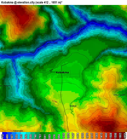
Below is the Elevation map of Kobakma, which displays elevation range with different colors. Scale of the first map is from 412 to 1651 m (1352 to 5417 ft) with average elevation of 940.3 meters (=3085 ft) [note 1]
These maps also provides idea of topography and contour of this city, they are displayed at different zoom levels. More info about maps, scale and edge coordinates you can find below images.
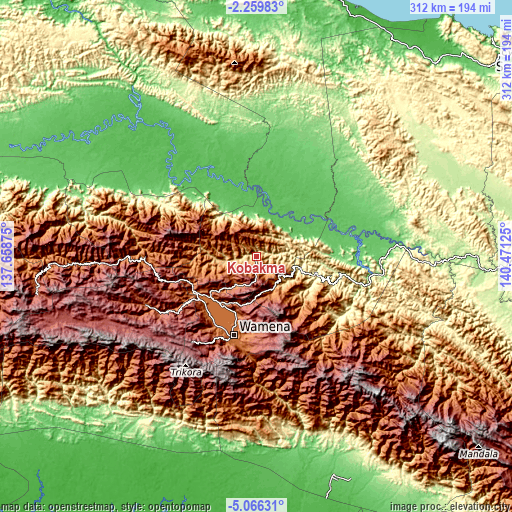
| \ | Map #1 | Topo.Map |
| Scale [m] | 412..1651 m | × |
| Scale [ft] | 1352..5417 ft | × |
| Average | 940.3 m = 3085 ft | × |
| Width | 9.75 km = 6.1 mi | 312.1 km = 193.9 mi |
| Height | 9.75 km = 6.1 mi | 312.1 km = 193.9 mi |
| ↑Max Latitude | -3.620313° | -2.25983° |
| Latitude at center | -3.66417° | -3.66417° |
| ↓Min Latitude | -3.708024° | -5.06631° |
| ← Min Longitude | 139.021055° | 137.65875° |
| Longitude center | 139.065° | 139.065° |
| →Max Longitude | 139.108945° | 140.47125° |
Nearby cities:
Cities around Kobakma sort by population:
• Armopa elevation 11 m
160.1 km,  23°
23°
• Guay 185 m
153.3 km,  32°
32°
• Kenyam 139 m
128.5 km,  215°
215°
• Mulia 2106 m
119.9 km,  267°
267°
• Sumohai 117 m
118.4 km,  164°
164°
• Tiom 2116 m
73.6 km,  246°
246°
• Elelim 142 m
72.1 km,  98°
98°
• Dabra 57 m
70.5 km,  311°
311°
• Karubaga 1781 m
67.5 km, 266°
• Bikondini 1789 m
54.4 km, 270°
• Wamena 1658 m
49.7 km,  195°
195°
• Wurigelebur 1568 m
30.5 km, 248°
Multilingual:
 En español:
Kobakma elevación 961 m.
 En France:
Kobakma élévation 961 m.


Sources and notes:
- [note 1] Map square and city borders are not equal. Map elevation data is calculated only from area inside that square.
- [src 1] Elevation data from geonames database provided with same terms of usage.
- [src 2] The elevation map of Kobakma is generated using elevation data from NASA's 3 arcsec (90m) resolution SRTM data.
- [src 3] Base (background) map © OpenStreetMap contributors tiles are generated by Geofabrik and OpenTopoMap.
Copyright & License:
This Kobakma Elevation Map is licensed under CC BY-SA. You may reuse any part from this page, if you give a proper credit by linking to this URL:
 More info on terms of use page.