Wasior elevation
Wasior (Papua), Indonesia elevation is 15 meters and Wasior elevation in feet is 49 ft above sea level [src 1]. Wasior is a seat of a third-order administrative division (feature code) with elevation that is 176 meters (577 ft) smaller than average city elevation in Indonesia.
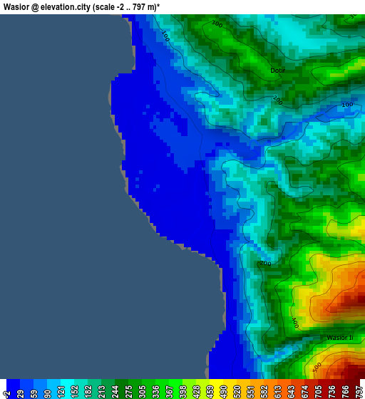
Below is the Elevation map of Wasior, which displays elevation range with different colors. Scale of the first map is from -2 to 797 m (-7 to 2615 ft) with average elevation of 191.5 meters (=628 ft) [note 1]
These maps also provides idea of topography and contour of this city, they are displayed at different zoom levels. More info about maps, scale and edge coordinates you can find below images.
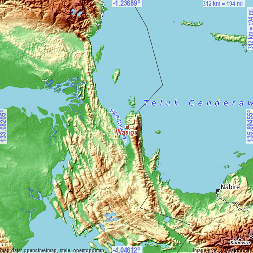
| \ | Map #1 | Topo.Map |
| Scale [m] | -2..797 m | × |
| Scale [ft] | -7..2615 ft | × |
| Average | 191.5 m = 628 ft | × |
| Width | 9.76 km = 6.1 mi | 312.4 km = 194.1 mi |
| Height | 9.76 km = 6.1 mi | 312.4 km = 194.1 mi |
| ↑Max Latitude | -2.598401° | -1.23689° |
| Latitude at center | -2.6423° | -2.6423° |
| ↓Min Latitude | -2.686198° | -4.04612° |
| ← Min Longitude | 134.444355° | 133.08205° |
| Longitude center | 134.4883° | 134.4883° |
| →Max Longitude | 134.532245° | 135.89455° |
Nearby cities:
Cities around Wasior sort by population:
• Nabire elevation 8 m
137.9 km,  125°
125°
• Ullong 1953 m
155.2 km,  335°
335°
• Kiruru 161 m
153.7 km,  159°
159°
• Topo 307 m
153.4 km, 130°
• Oransbari 11 m
146.6 km,  349°
349°
• Kaimana 6 m
139.1 km,  215°
215°
• Ransiki 26 m
130.9 km, 344°
• Bintuni 95 m
121.2 km,  299°
299°
• Babo 20 m
119.2 km,  275°
275°
• Bofuer 29 m
90.4 km,  243°
243°
• Kwantisore 18 m
83.4 km,  146°
146°
• Rasiei 30 m
19.9 km,  166°
166°
Multilingual:
 En español:
Wasior elevación 15 m.
 En France:
Wasior élévation 15 m.


Sources and notes:
- [note 1] Map square and city borders are not equal. Map elevation data is calculated only from area inside that square.
- [src 1] Elevation data from geonames database provided with same terms of usage.
- [src 2] The elevation map of Wasior is generated using elevation data from NASA's 3 arcsec (90m) resolution SRTM data.
- [src 3] Base (background) map © OpenStreetMap contributors tiles are generated by Geofabrik and OpenTopoMap.
Copyright & License:
This Wasior Elevation Map is licensed under CC BY-SA. You may reuse any part from this page, if you give a proper credit by linking to this URL:
 More info on terms of use page.