Nabire elevation
Nabire (Papua), Indonesia elevation is 8 meters and Nabire elevation in feet is 26 ft above sea level [src 1]. Nabire is a seat of a second-order administrative division (feature code) with elevation that is 183 meters (600 ft) smaller than average city elevation in Indonesia.
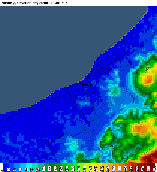
Below is the Elevation map of Nabire, which displays elevation range with different colors. Scale of the first map is from 0 to 401 m (0 to 1316 ft) with average elevation of 60.5 meters (=198 ft) [note 1]
These maps also provides idea of topography and contour of this city, they are displayed at different zoom levels. More info about maps, scale and edge coordinates you can find below images.
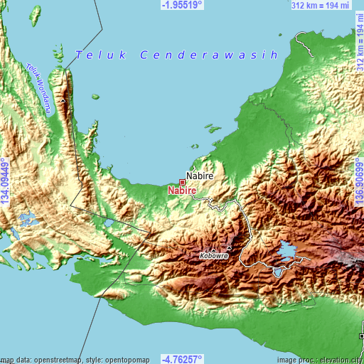
| \ | Map #1 | Map #2 | Topo.Map |
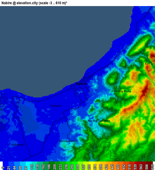
| Scale [m] | 0..401 m | -3..610 m | × |
| Scale [ft] | 0..1316 ft | -10..2001 ft | × |
| Average | 60.5 m = 198 ft | 135.1 m = 443 ft | × |
| Width | 9.76 km = 6.1 mi | 19.51 km = 12.1 mi | 312.2 km = 194 mi |
| Height | 9.76 km = 6.1 mi | 19.51 km = 12.1 mi | 312.2 km = 194 mi |
| ↑Max Latitude | -3.316019° | -3.272147° | -1.95519° |
| Latitude at center | -3.35989° | -3.35989° | -3.35989° |
| ↓Min Latitude | -3.403759° | -3.447626° | -4.76257° |
| ← Min Longitude | 135.456795° | 135.412849° | 134.09449° |
| Longitude center | 135.50074° | 135.50074° | 135.50074° |
| →Max Longitude | 135.544685° | 135.588631° | 136.90699° |
Nearby cities:
Cities around Nabire sort by population:
• Kumopa elevation 2450 m
123.1 km,  114°
114°
• Enarotali 1788 m
116 km,  123°
123°
• Waghete 1709 m
114.4 km,  131°
131°
• Homeyo 1359 m
112.6 km, 107°
• Tigi 1772 m
108.5 km, 128°
• Obano 2160 m
102.2 km, 128°
• Moanemani 1569 m
95.7 km, 134°
• Kiruru 161 m
87.3 km,  222°
222°
• Bomomani 1129 m
86 km,  155°
155°
• Kigamani 1582 m
83 km,  143°
143°
• Kwantisore 18 m
66.8 km,  279°
279°
• Topo 307 m
20.5 km,  168°
168°
Multilingual:
 En español:
Nabire elevación 8 m.
 En France:
Nabire élévation 8 m.


Sources and notes:
- [note 1] Map square and city borders are not equal. Map elevation data is calculated only from area inside that square.
- [src 1] Elevation data from geonames database provided with same terms of usage.
- [src 2] The elevation map of Nabire is generated using elevation data from NASA's 3 arcsec (90m) resolution SRTM data.
- [src 3] Base (background) map © OpenStreetMap contributors tiles are generated by Geofabrik and OpenTopoMap.
Copyright & License:
This Nabire Elevation Map is licensed under CC BY-SA. You may reuse any part from this page, if you give a proper credit by linking to this URL:
 More info on terms of use page.