Maritaing elevation
Maritaing (East Nusa Tenggara), Indonesia elevation is 16 meters and Maritaing elevation in feet is 52 ft above sea level [src 1]. Maritaing is a seat of a third-order administrative division (feature code) with elevation that is 175 meters (574 ft) smaller than average city elevation in Indonesia.
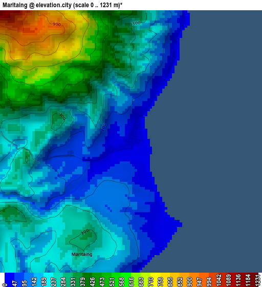
Below is the Elevation map of Maritaing, which displays elevation range with different colors. Scale of the first map is from 0 to 1231 m (0 to 4039 ft) with average elevation of 276.7 meters (=908 ft) [note 1]
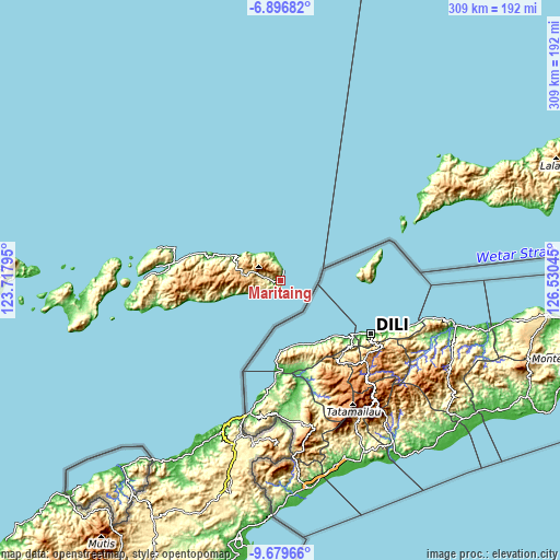
These maps also provides idea of topography and contour of this city, they are displayed at different zoom levels. More info about maps, scale and edge coordinates you can find below images.
| \ | Map #1 | Topo.Map |
| Scale [m] | 0..1231 m | × |
| Scale [ft] | 0..4039 ft | × |
| Average | 276.7 m = 908 ft | × |
| Width | 9.67 km = 6 mi | 309.4 km = 192.3 mi |
| Height | 9.67 km = 6 mi | 309.5 km = 192.3 mi |
| ↑Max Latitude | -8.247212° | -6.89682° |
| Latitude at center | -8.2907° | -8.2907° |
| ↓Min Latitude | -8.334184° | -9.67966° |
| ← Min Longitude | 125.080255° | 123.71795° |
| Longitude center | 125.1242° | 125.1242° |
| →Max Longitude | 125.168145° | 126.53045° |
Nearby cities:
Cities around Maritaing sort by population:
• Atambua elevation 336 m
94.2 km,  195°
195°
• Wairiang 26 m
144.1 km,  274°
274°
• Betun 21 m
143.9 km,  189°
189°
• Baranusa 17 m
114.2 km, 266°
• Kabir 6 m
100.2 km, 272°
• Kokar 9 m
75.8 km,  280°
280°
• Kampungraja 21 m
67.3 km, 277°
• Moru 20 m
67.1 km, 273°
• Kalabahi 33 m
64.2 km, 277°
• Mainang 829 m
54.9 km, 270°
• Apui 770 m
44.2 km, 272°
• Kemang 39 m
43 km,  288°
288°
Multilingual:
 En español:
Maritaing elevación 16 m.
 En France:
Maritaing élévation 16 m.
 Auf Deutsch:
Maritaing höhe über dem Meeresspiegel ist 16 m.

Sources and notes:
- [note 1] Map square and city borders are not equal. Map elevation data is calculated only from area inside that square.
- [src 1] Elevation data from geonames database provided with same terms of usage.
- [src 2] The elevation map of Maritaing is generated using elevation data from NASA's 3 arcsec (90m) resolution SRTM data.
- [src 3] Base (background) map © OpenStreetMap contributors tiles are generated by Geofabrik and OpenTopoMap.
Copyright & License:
This Maritaing Elevation Map is licensed under CC BY-SA. You may reuse any part from this page, if you give a proper credit by linking to this URL:
 More info on terms of use page.